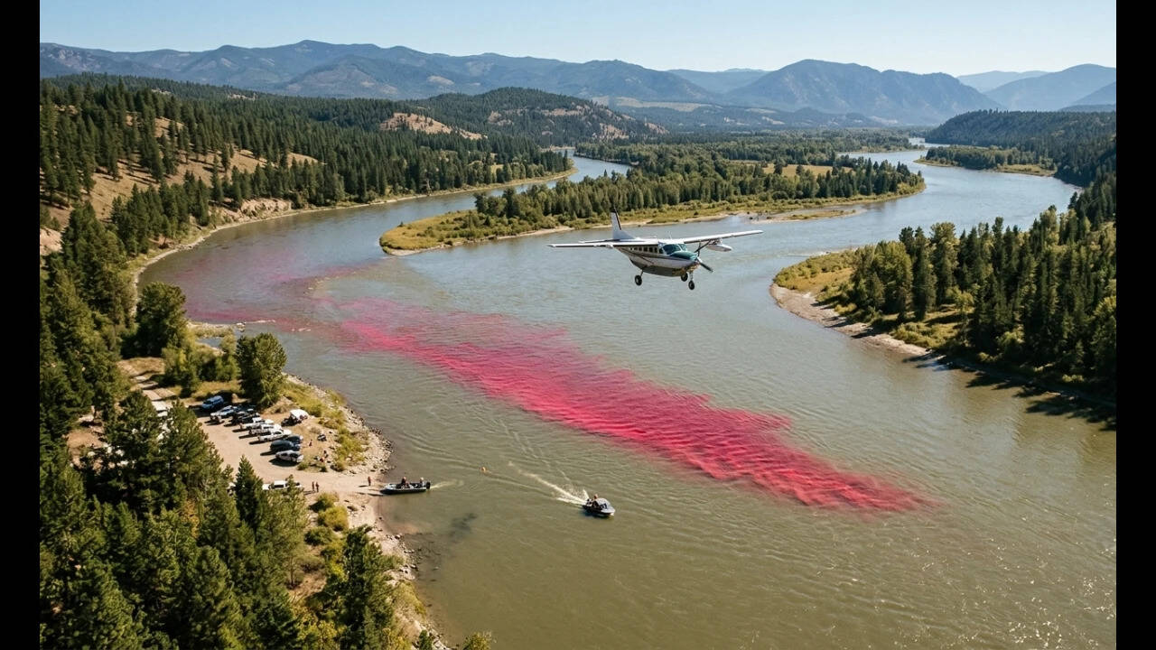
Quantifying hydrodynamic dispersion in natural river channels has historically relied on sparse point-source data collection, creating spatial blind spots that compromise numerical hydraulic models. In September 2017, the United States Geological Survey executed a controlled mass injection of 72.57 kilograms of Rhodamine WT tracer dye into Idaho's Kootenai River over a 90-second window, coupling traditional in-stream fluorometry with airborne hyperspectral remote sensing. This operational blueprint restructured how hydrologists map scalar transport, transient storage zones, and momentum dissipation in complex open-channel networks.
The Mechanics of Mass Injection and Advective Transport
Traditional tracer methodologies suffer from poor spatial resolution, relying on discrete, anchored water-quality sondes that record temporal passage curves at isolated cross-sections. While these fixed-point instruments accurately measure concentration decay over time at specific coordinates, they fail to capture transverse mixing dynamics and longitudinal stretching across irregular geometries.
During the Kootenai River deployment, researchers initiated a point-source pulse input near the Kootenai Tribal Fish Hatchery under a steady mean discharge regime of 198.4 cubic meters per second. The 72.57-kilogram payload of Rhodamine WT—a synthetic, water-soluble red xanthene tracer approved for environmental transport studies—dispersed through a reach characterized by varying sinuosity and bathymetric heterogeneity.
Advection dictates the bulk translation of the solute mass downstream at the mean flow velocity, whereas mechanical dispersion governs the spreading of the plume driven by velocity gradients and turbulent eddies. By discharging the total mass within a compressed 90-second interval, the experiment established an acute, high-concentration step-input function, optimizing the signal-to-noise ratio required for subsequent optical detection.
Airborne Hyperspectral Architecture Versus In-Situ Sensing
To bridge the gap between continuous temporal logs and continuous spatial tracking, the survey incorporated an ITRES CASI 1500H hyperspectral imaging system mounted on a manned Cessna Caravan aircraft, flying at an altitude of approximately 1,000 meters. Operating across 48 discrete spectral bands spanning wavelengths from 380 to 1,050 nanometers, the aerial sensor captured high-resolution spatial arrays of the moving plume.
The integration of remote sensing with fluvial mechanics introduces the Optimal Band Ratio Analysis algorithm. Rhodamine WT absorption alters the water-leaving radiance spectrum. By evaluating mathematical combinations of spectral reflectance bands, analysts establish robust empirical correlations between surface pixel values and actual dye concentrations measured in-stream.
This optical inversion model converts two-dimensional spatial imagery into continuous concentration maps. Each pixel, measuring 0.5 meters on a side, functions effectively as a remote fluorometer. Consequently, researchers transcend the limitations of linear sensor strings, mapping transverse concentration gradients, secondary circulation patterns, and dead-zone trapping mechanisms with unprecedented geometric fidelity.
Numerical Model Calibration and Ecological Applications
The empirical dataset generated by the Kootenai River test serves a dual engineering purpose: validating hydrodynamic routing equations and supporting endangered species management. One-dimensional and two-dimensional flow routing models—such as USGS surface-water models—require calibration parameters representing longitudinal dispersion coefficients and friction factors. Field-verified hyperspectral imagery provides the necessary validation constraints to tune these parameters against physical reality.
For ecological restoration, mapping scalar dispersion mirrors the transport mechanics of suspended sediments, thermal plumes, and larval aquatic organisms. On the Kootenai River, understanding flow velocity profiles and retention zones is directly tied to the habitat survival of the endangered burbot and white sturgeon. Larval drift dynamics depend entirely on localized hydraulic bottlenecks where low-velocity pockets permit or impede downstream migration.
Operational Bottlenecks and Methodological Constraints
Despite the analytical elevation provided by airborne hyperspectral tracking, optical remote sensing of river plumes remains bounded by specific physical constraints:
- Surface Glint and Illumination: Direct solar specular reflection distorts water-leaving radiance, requiring precise flight-path timing and cloud-cover mitigation.
- Radiometric Calibration Drift: Atmospheric attenuation and shifting illumination angles demand rigorous, real-time in-situ ground-truthing via boat-mounted spectroradiometers.
- Optical Depth Limitations: Passive optical methods measure surface concentrations; highly turbid waters restrict signal penetration, obscuring vertical mixing profiles within the water column.
Deploy hydrodynamic models driven by dual-domain calibration. Pair high-frequency in-stream fluorometry arrays with targeted airborne hyperspectral passes during stable baseflow conditions to eliminate spatial interpolation errors in critical watershed management operations.