So, you're planning a trip to Yosemite and the first thing you do—naturally—is check the fire situation. You’ve probably seen those scary-looking red blobs on a map and felt your heart sink. But here’s the thing: looking at a yosemite park fire map without knowing how to read it is like trying to navigate the backcountry with a grocery store flyer. It’s technically a map, sure, but it’s not giving you the full story.
Honestly, people freak out the second they see a "fire" icon near the Valley. Usually, it's just a small lightning-strike fire at 9,000 feet that’s doing exactly what it's supposed to do—cleaning up the forest floor. Or, it's a prescribed burn where the park service is literally setting fires on purpose to save the giant sequoias. Meanwhile, you can explore similar developments here: The Hyperventilating Media Coverage of Tourist Transport is Distorting Real Travel Safety.
The reality of fire in Yosemite is way more nuanced than "is it burning or not?"
Why the Red Blobs on Your Map Are Often Liars
When you pull up a standard fire tracker, you’re often looking at satellite "hotspots." These are heat signatures detected from space. They don't differentiate between a massive wall of flames and a smoldering log in a granite basin. To understand the complete picture, we recommend the excellent article by Condé Nast Traveler.
Take the Middle Fire from last season, for example. It showed up on maps as a concerning patch near Tioga Road. If you just looked at the icon, you’d think the road was toasted. In reality? Crews were using a full suppression strategy, but the fire was mostly chewing through brush in a remote area. The "perimeter" on a map is often just a rough estimate, not a solid line of fire.
The National Park Service (NPS) often manages these as "confine and contain" incidents. This means they let the fire do its thing within a specific box of rocks and ridges. If you see a yosemite park fire map with a large outlined area, it might just be the "management zone," not the actual fire.
Where to Actually Find the Truth
If you want the real-time, boots-on-the-ground data, stop using generic weather apps. You need the stuff the pros use:
- InciWeb: This is the gold standard. It’s the interagency system where every major fire gets its own page with maps, photos, and—most importantly—daily updates from the Incident Commander.
- AirNow Fire and Smoke Map: This is arguably more important than the fire map itself. A fire could be 20 miles away, but if the wind shifts, the Valley becomes a bowl of gray soup. This map shows you the PM2.5 levels (the tiny bits of burnt stuff that make you cough).
- PurpleAir: This is a network of low-cost sensors. Because NPS monitors can be sparse, PurpleAir gives you hyper-local data. If a sensor near El Capitan is purple, don't go hiking.
The Weird Paradox of the 2026 Season
We’re in a strange spot right now. As of early 2026, there’s been some chatter about how the recent federal government shutdown messed with the "burn windows." Expert Cassius Cash, who leads the Yosemite Conservancy, recently pointed out that when the government stops, the prescribed fires stop too.
That matters because those small, controlled fires are what prevent the "megafires" like the Rim Fire of 2013 or the Washburn Fire of 2022. If we miss a season of pile burning—where rangers burn literal piles of dead wood—the forest essentially becomes a tinderbox.
So, if you look at a yosemite park fire map in February and see nothing, that’s not always good news. It might mean the fuel is just sitting there, waiting for a dry July and a single lightning strike.
The "Firefall" Confusion
Don't confuse the "Firefall" with an actual wildfire. I know it sounds silly, but tourists do it every year. In February, Horsetail Fall glows orange in the sunset, looking exactly like lava. It’s a natural light show, not a forest fire.
Interestingly, for the 2026 season, Superintendent Ray McPadden announced they’ve scrapped the reservation system for the Firefall event. This is a huge shift. Expect chaos. If you're checking maps for "fire" in February, you're likely just seeing traffic alerts for the thousands of people trying to see a glowing waterfall.
How Smoke Re-Maps Your Trip
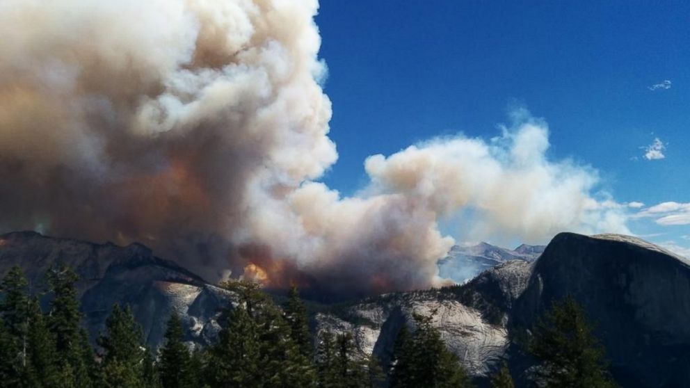
The map says the fire is in the backcountry. The trails you want are open. You think you're golden. Then you arrive, and you can’t see Half Dome from the parking lot.
Smoke is the great "trip-killer." In Yosemite, the topography creates an "inversion layer." At night, cool air sinks into the Valley, trapping smoke near the ground. By noon, the sun heats things up, and the smoke usually lifts and clears out.
If you're looking at a yosemite park fire map and see active incidents, check the "Smoke Outlooks." These are specialized PDF maps released by NPS that show exactly where the plume is expected to drift at 8:00 AM versus 4:00 PM. It’s the difference between a scenic hike and a lung-burning mistake.
Reading Between the Lines of Park Closures
Yosemite rarely closes the whole park. They’re more like a scalpel than a sledgehammer.
When the Washburn Fire threatened the Mariposa Grove, they didn't shut down the Valley. They shut down the South Entrance and Wawona. People saw "Yosemite Fire" on the news and canceled their hotel in Groveland—which was totally fine!
Before you cancel, look at the specific "Incident Map" on InciWeb. Check if the "Planning Area" overlaps with your intended trails. Often, a fire 10 miles away has zero impact on your ability to walk the Mist Trail or see Yosemite Falls.
Your Wildfire Survival Checklist for 2026
Forget the generic "stay safe" advice. If you're heading into the park this year, do this:
- Download the NPS App for Offline Use: Cell service in the park is basically non-existent. The app has a "Fire" section that caches the latest alerts.
- Text YNPTRAFFIC to 333111: Fire often causes road closures or one-way traffic controls. This text service is the fastest way to get notified.
- Check the Webcams: If the yosemite park fire map looks scary, look at the Half Dome or High Sierra webcams. If the sky is blue, the map might be lagging behind the actual conditions.
- Watch the 6,000-Foot Line: Most fire restrictions kick in below 6,000 feet first because it's drier and hotter. If you're camping at North Pines or Lower Pines (Valley floor), you're more likely to face wood fire bans than if you're up at Tuolumne Meadows.
Fire is part of the Sierra Nevada. It’s been burning here since before the first human stepped into the Valley. Instead of fearing the yosemite park fire map, use it as a tool to find the clear air and the safe paths.
Before you head out, pull up the AirNow map and cross-reference it with the current InciWeb perimeters. If the AQI is under 50 and the fire is moving away from the drainage you’re in, you’re likely in for a spectacular trip. Just remember to pack a N95 mask in your glovebox—not for the flames, but for the smoke that can roll in faster than a summer thunderstorm.