If you’ve ever driven across the Bay Bridge, you know the moment. You’re halfway between the glimmering skyline of San Francisco and the cranes of Oakland when suddenly, you’re inside a tunnel. That’s Yerba Buena Island San Francisco. Most people just call it a pass-through. A rock in the middle of the water. For decades, it was basically just a place where the Coast Guard lived and where commuters held their breath while merging onto the lower deck.
But honestly? Things are changing so fast out there it’s kind of hard to keep up.
We aren't talking about a few new benches. We’re talking about a multi-billion dollar pivot from a sleepy military outpost to one of the most expensive, exclusive, and structurally complex neighborhoods in the United States. If you haven't been there in the last year, you probably wouldn't even recognize the hilltop. The old Navy housing—those "Great Gatsby" looking buildings—is still there, but it's now surrounded by sleek glass towers and townhomes that look like they belong in a Bond movie.
The Yerba Buena Island San Francisco Reality Check
There is a huge misconception that Yerba Buena and Treasure Island are the same thing. They aren't. Not even close.
Yerba Buena is the natural, rocky outcrop. It’s the anchor. Treasure Island is the flat, man-made pancake attached to its north side, built out of dredged bay mud for the 1939 Golden Gate International Exposition. While Treasure Island is currently a massive construction site dealing with complex soil stabilization (basically making sure the ground doesn't turn to liquid during an earthquake), Yerba Buena Island is solid rock.
That rock is the foundation for some of the most ambitious engineering projects in the Bay Area. Because it’s a steep, wind-swept island, building here is a nightmare. Everything has to be barged in or driven through that single, cramped bridge exit. You've got to deal with 100-foot elevation changes and the kind of salt spray that eats through cheap materials in weeks.
Why the Navy Left (and Why Developers Moved In)
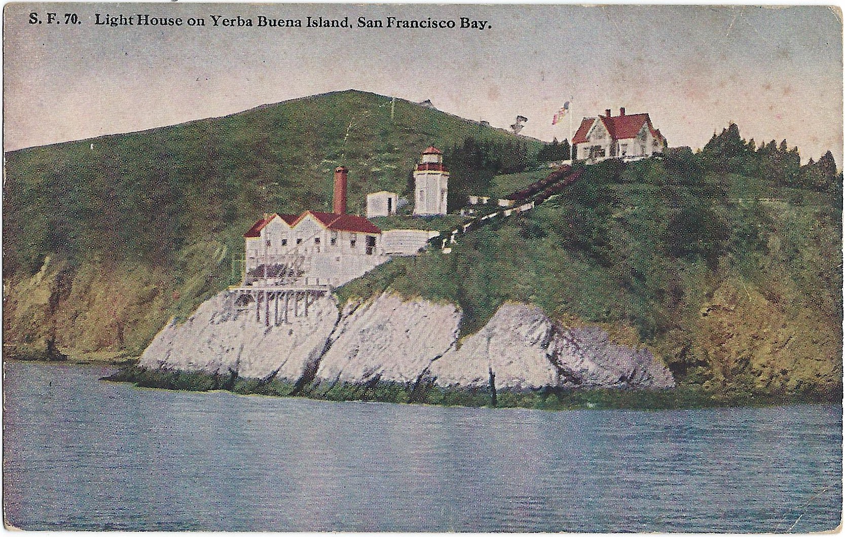
The Naval Training Station on Yerba Buena was commissioned back in 1898. It was a big deal. Then came the 1990s and the Base Realignment and Closure (BRAC) process. The military packed up, leaving behind a weird, ghost-town vibe. For a long time, it was just... there.
Now, the Treasure Island Development Authority (TIDA) is overseeing a plan that will eventually bring 8,000 homes to these two islands. But the Yerba Buena side is the "luxury" side. Think of it as the penthouse of the San Francisco Bay. While Treasure Island will be high-density, Yerba Buena is about the views.
The views are actually ridiculous. On a clear day, you can see the Golden Gate, Alcatraz, and the entire San Francisco waterfront without even turning your head. It’s arguably the best vantage point in Northern California.
The Infrastructure Nobody Talks About
Most people visiting Yerba Buena Island San Francisco focus on the new condos, but the real story is the dirt. And the pipes.
To make this island livable for thousands of new residents, the city had to completely overhaul the utilities. We’re talking about a brand-new water reservoir and a massive new ferry terminal. The ferry is the real game-changer. For years, if you lived on the island, you were a slave to the Bay Bridge traffic. If there was a stall on the bridge, you were stuck. Period.
Now, the Treasure Island Ferry runs between the island and the San Francisco Ferry Building. It takes about 10 minutes. It's smooth. It's fast. It’s basically the coolest commute in the world, and it has turned the island from an isolated rock into a viable neighborhood for people who work in the Financial District.
- Hilltop Park: This is the crown jewel. Designed by Hood Design Studio (the same folks who did the De Young Museum landscaping), it sits at the highest point of the island.
- The Infinite Light: There’s a massive 70-foot sculpture by Hiroshi Sugimoto called "Point of Infinity" that acts as a sundial. It’s meant to be seen from the bridge.
- The Trails: There are miles of new hiking and biking trails that wrap around the cliffs.
Is it Actually Safe?
People always ask about earthquakes. It’s San Francisco, so it’s a fair question.
Because Yerba Buena Island is Franciscan bedrock, it’s actually one of the safest places to be during a tremor compared to the "reclaimed" land of the Marina or even parts of SOMA. The buildings are anchored directly into the stone. The developers, Wilson Meany and Lennar, had to meet some of the most stringent seismic codes ever written.
There's also the "isolated" factor. There is no grocery store on the island yet. There’s no gas station. If you forget milk, you’re either taking a ferry or brave-hearting the Bay Bridge merge to get to the Safeway on Diamond Heights or the Whole Foods in SOMA. It’s a trade-off. You get total silence and 360-degree ocean views, but you lose the convenience of city living.
The Politics of the Island
You can't talk about Yerba Buena Island San Francisco without mentioning the tension over housing. This is San Francisco, after all.
Critics have pointed out that the first phase of development on Yerba Buena was heavily skewed toward "ultra-luxury." When the Bristol (the first big condo building) opened, the prices were eye-watering. People wondered if the island was just becoming a gated community for tech billionaires.
However, the broader Treasure Island/Yerba Buena project actually includes a significant mandate for affordable housing. About 27% of the total 8,000 units are designated as affordable. The "luxury" sales on the hill are essentially subsidizing the massive infrastructure costs and the affordable units down on the flats of Treasure Island. It’s a complicated, fragile financial ecosystem.
Wildlife and the "Wild" Side
Despite all the concrete and glass, the island is surprisingly wild.
It’s a major stop for migratory birds. You’ll see red-tailed hawks circling the peaks and plenty of cormorants down by the rocks. There have even been sightings of gray foxes. Because much of the island’s perimeter is too steep to build on, large swathes of it will remain "natural." This creates a weird contrast where you have a $3 million condo sitting fifty yards away from a sheer cliff covered in native succulents and nesting seabirds.
How to Actually Visit Yerba Buena Island Today
If you want to check it out, don't just drive through the tunnel and hope for the best.
- Take the Ferry: Honestly, skip the car. Park at the Embarcadero and hop the ferry. It’s $5 and way more fun.
- Walk the Macalla Road: This is the main artery that loops up the hill. It’s steep. Your calves will burn. But the views of the Bay Bridge eastern span—the white self-anchored suspension part—are incredible.
- Check the Fog: If the city is "socked in," the island is usually even foggier. Wait for a day when the wind is blowing from the North for the best visibility.
- Visit the Quarters: Look for "Quarters 10" and the surrounding historic buildings. This was the Senior Officers' housing back in the day. Admiral Chester Nimitz lived here. It’s a trip to see the 1900-era architecture standing next to 2026-era modernism.
What’s Next for the Island?
We are currently in the middle of a ten-year build-out.
By 2028, the "commercial core" of the islands should be more established. We’re expecting more restaurants, a few small shops, and hopefully a dedicated school site. Right now, it’s still very much a "pioneer" phase. The people living there now are willing to deal with the construction noise and the lack of a CVS in exchange for being the first ones to own a piece of the Bay’s newest neighborhood.
Yerba Buena Island is a weird, beautiful, clunky, and expensive experiment. It’s San Francisco trying to figure out how to grow when there’s no more land left. By building "up" on a rock in the middle of the water, the city is creating a new identity that isn't quite downtown and isn't quite the suburbs. It’s something else entirely.
If you’re planning a trip or thinking about moving, keep in mind that the island is a construction zone first and a park second—at least for now. But once you stand at the top of Hilltop Park and watch the sunset hit the Transamerica Pyramid, you kind of get why they’re spending billions to be there.
Actionable Next Steps for Visiting Yerba Buena Island:
- Download the Treasure Island Ferry app to check real-time schedules, as they can change based on weather or bay conditions.
- Pack layers. The temperature on the island is usually 5 to 10 degrees cooler than the mainland due to the wind tunnel effect of the Bay Bridge.
- Bring a camera with a zoom lens. The angles you get of the San Francisco skyline from the western cliffs are unique and can't be found anywhere else in the city.
- Check the TIDA (Treasure Island Development Authority) website before you go to see if any specific trails or roads are closed for active construction, which happens frequently.
- Skip the weekend driving. Traffic on the Bay Bridge during Saturday and Sunday afternoons makes getting on and off the island a nightmare; the ferry remains the most reliable entry point.