Most people look at a map of the American West and assume the drive from Yellowstone Park to Mt Rushmore is just a quick afternoon jaunt. It isn't. You’re looking at about 450 to 500 miles of high-desert plains, winding mountain passes, and long stretches where the only company you'll have is a stray pronghorn or a radio station playing classic country from 1984. It is arguably one of the most iconic road trips in the United States, but if you don't time it right, you’ll spend ten hours staring at a steering wheel instead of seeing the sights.
You've got two main ways to do this. You can take the "fast" route through Casper, Wyoming, which is basically a lot of flat road and wind. Or, you can take the scenic northern route through the Bighorn Mountains. Honestly, if you choose the highway just to save an hour, you're doing it wrong. The Bighorns are where the real magic happens.
Why the Bighorn Mountains are the Secret MVP
Let’s talk about U.S. Route 14. This is the road that takes you over the crest of the Bighorns. It’s steep. Like, "check your brakes before you start" steep. But once you get to the top, the view of the Powder River Basin is enough to make you pull over and just breathe for a second. Most travelers heading from Yellowstone Park to Mt Rushmore rush through this part because they’re focused on the destination. That’s a mistake.
Ten Sleep Canyon is on this route. It’s named that because it supposedly took ten sleeps to reach from the main Sioux camps. The limestone walls there are massive. It’s a climber’s paradise, but even if you don’t own a harness, the sheer scale of the rock faces is intimidating.
The Shell Falls Stop
Right off the highway is Shell Falls. It's not the biggest waterfall you’ll ever see, but the geology is wild. You’re looking at 2.9 billion-year-old Granite. That’s nearly two-thirds the age of the Earth. There’s a small interpretive center there, usually staffed by folks who know every bird species in the canyon. It’s a perfect fifteen-minute leg stretch.
Cody, Wyoming: More Than Just a Gateway
Before you even get into the mountains, you have to pass through Cody. Buffalo Bill Cody founded this place, and he didn't do it quietly. The Buffalo Bill Center of the West is actually five different museums under one roof. It’s often called the "Smithsonian of the West." You can see firearms, Plains Indian artifacts, and fine art.
If you're there in the summer, the Cody Nite Rodeo is a thing. It’s every single night. It’s touristy, sure, but it’s authentic touristy. You’ll see kids barely old enough to walk riding sheep (mutton busting) and actual cowboys trying not to get bucked into the dirt. It’s a loud, dusty, fun way to spend an evening before you head east toward the Black Hills.
The Chief Joseph Scenic Byway
If you have an extra two hours, take the Chief Joseph Scenic Byway (Wyoming Highway 296) out of Cooke City. It connects back to Cody. This road follows the route the Nez Perce took in 1877 while fleeing the U.S. Cavalry. The Sunlight Bridge is the highest bridge in Wyoming. Looking down into the gorge from there will give you vertigo, guaranteed.
Crossing the "Empty" Middle
Once you clear the Bighorns and pass through Buffalo, Wyoming, the landscape changes. It gets flat. It gets dry. This is the stretch where most people get bored on the way from Yellowstone Park to Mt Rushmore.
Gillette is the big town here. It’s a coal mining hub. You might see massive trains—sometimes over a mile long—carrying coal east. It’s a different kind of scenery, industrial and rugged.
Devils Tower: The Big Side Trip
You cannot drive this route and skip Devils Tower National Monument. It’s about 30 miles off the main path, but it’s essential. It was the first National Monument in the U.S. for a reason. The Lakota call it Bear Lodge. The columnar basalt rises 1,267 feet above the Belle Fourche River.
Walk the 1.3-mile Tower Trail around the base. You’ll see prayer cloths tied to the trees. These are sacred religious offerings from indigenous tribes. Don't touch them. Just observe. The sound of the wind through the pines there is unlike anywhere else; it’s quiet, even when there are tourists around.
Entering the Black Hills
When you finally cross the border into South Dakota, the dirt turns red. That’s the Spearfish Formation. It signals you've entered the Black Hills. Spearfish Canyon is a lush, green contrast to the Wyoming plains.
- Bridal Veil Falls: Right on the side of the road.
- Roughlock Falls: A bit of a hike, but worth the effort for the photos.
- Film History: Parts of Dances with Wolves were filmed in this canyon.
Deadwood is nearby. It’s a gambling town now, but it’s built on the bones of the 1876 gold rush. Wild Bill Hickok was shot here. Calamity Jane is buried here. It feels a bit like a movie set, but the history is very real.
The Final Stretch: Mt Rushmore and Beyond
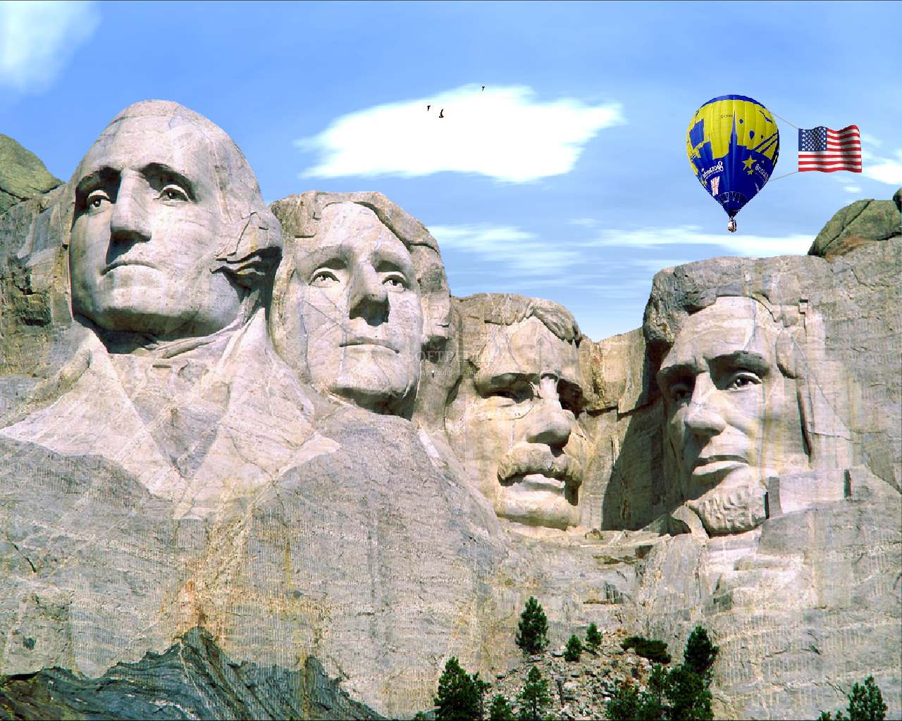
Finally, you reach the faces. Seeing Yellowstone Park to Mt Rushmore in one trip shows you two very different versions of America. Yellowstone is about the raw, untamed power of the Earth—geysers, bears, and sulfur. Mt Rushmore is about the human attempt to leave a mark on that Earth.
The sculpture was carved by Gutzon Borglum and his son Lincoln between 1927 and 1941. Most people don't realize that the workers used dynamite for 90% of the carving. It wasn't just guys with chisels; it was a massive engineering project involving precarious cable cars and tons of explosives.
The Evening Lighting Ceremony
If you can, time your arrival for the evening. The National Park Service does a lighting ceremony that is significantly more moving than just seeing the mountain during the day. They bring veterans up on stage and lower the flag. It’s patriotic, a little old-fashioned, and very poignant against the backdrop of the illuminated presidents.
Common Mistakes to Avoid
Don't rely on your GPS to give you accurate times. It doesn't account for "bison jams." In Yellowstone, a single bison standing in the road can back up traffic for three miles. You’ll sit there for forty-five minutes while people take pictures out of their windows. Just accept it. It's part of the experience.
Fuel up whenever you see a gas station in eastern Wyoming. Seriously. There are stretches of I-90 and U.S. 14 where you won't see a pump for fifty miles. Also, cell service is spotty. Download your maps for offline use before you leave West Yellowstone or Gardiner.
The Weather Factor
The weather on the drive from Yellowstone Park to Mt Rushmore is erratic. You can have a 70-degree day in Cody and a blizzard on Granite Pass in the Bighorns two hours later. This can happen in June. I'm not kidding. Pack layers even if you’re traveling in the middle of summer.
Making the Most of Your Trip
If you want the best experience, give yourself at least two full days for the drive itself. Sure, you can do it in eight hours if you drive like a maniac and don't stop, but you'll miss everything that makes the American West special.
- Start in Yellowstone at sunrise. Hit the Lamar Valley for wolf and grizzly sightings.
- Exit through the Northeast Entrance (Silver Gate/Cooke City).
- Drive the Beartooth Highway if it’s open (late May to September). It’s often called the most beautiful drive in America.
- Stay overnight in Cody or Buffalo, Wyoming.
- Hit Devils Tower the next morning.
- Roll into the Black Hills by late afternoon.
This pace allows you to actually see the transition from the volcanic plateau of the Rockies to the ancient, weathered peaks of the Black Hills. You’ll notice the change in the trees, the smell of the air, and even the color of the grass.
Pro-Tip: Buy a "Beautiful the Beautiful" National Parks Pass before you start. It costs 80 dollars but covers entry for Yellowstone, Devils Tower, and the parking fee at Mt Rushmore. It pays for itself by the time you reach South Dakota.
Check the Wind: If you’re driving a high-profile vehicle or pulling a trailer, watch the Wyoming wind alerts. The gusts across the plains near Gillette can be strong enough to flip a camper. If the signs say "closed to light, high-profile vehicles," they mean it. Stop at a diner, get some pie, and wait it out.
The trip from Yellowstone Park to Mt Rushmore is a rite of passage. It links the geothermal weirdness of the world's first national park with the monumental scale of the Black Hills. Take the back roads. Eat at a greasy spoon in Greybull. Look at the stars in a place with zero light pollution. That’s where the real story of the West is.