You’ve probably heard that Cody is the "Gateway to Yellowstone." It sounds like a marketing slogan, but honestly, it’s just the literal truth. If you’re standing in downtown Cody, grabbing a coffee at Rawhide Coffee Co., you aren't just close to the park—you’re basically on its front porch. But here is where the confusion starts. People ask how far is Yellowstone National Park from Cody Wyoming and expect a single number.
The reality? It depends on which "Yellowstone" you're looking for.
Are we talking about the park boundary line? The visitor centers? The geysers? Yellowstone is roughly 3,500 square miles. That is larger than Rhode Island and Delaware combined.
The Quick Answer (And the "Real" One)
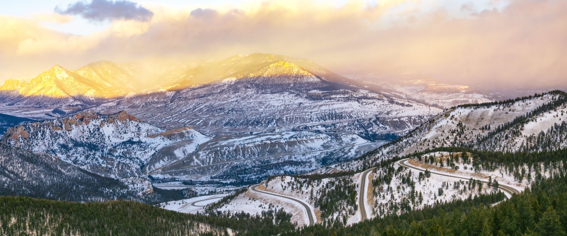
The East Entrance is the closest point of entry. It is exactly 52 miles from downtown Cody. If you hop on US Highway 14/16/20 (the Buffalo Bill Scenic Byway), you can hit the park gate in about an hour.
But—and this is a big "but"—getting to the gate isn't the same as arriving at the stuff you actually want to see.
Once you pass that East Entrance kiosk, you still have about 27 miles of winding mountain road to climb before you even reach Fishing Bridge and Yellowstone Lake. That’s another 45 minutes to an hour of driving, depending on whether a grizzly bear decided to take a nap near the shoulder.
Two Paths into the Wild
Cody is unique because it’s the only gateway town that gives you easy access to two different entrances. Most people just stick to the East Gate, but locals know the "back way" is often more spectacular.
1. The East Entrance (The Buffalo Bill Scenic Byway)
This is the classic route. You’ll head west out of town, passing the Buffalo Bill Dam and Reservoir. Teddy Roosevelt once called this stretch of road "the most scenic 50 miles in the world."
He wasn't exaggerating.
You’ll drive through the Wapiti Valley, characterized by bizarre rock formations called "hoodoos" and red-rock cliffs. It’s a prime spot for spotting bighorn sheep and elk before you even pay your entrance fee.
2. The Northeast Entrance (The Chief Joseph Scenic Byway)
If you have a bit more time, take Highway 120 north out of Cody and turn onto Highway 296. This is the Chief Joseph Scenic Byway. It’s about 80 miles from Cody to the Northeast Entrance near Cooke City.
The distance is longer, but the payoff is massive. You’ll climb over Dead Indian Pass, where the views of the Sunlight Basin will make your head spin. This route drops you right into the Lamar Valley—often called the "Serengeti of North America"—where wolves and massive bison herds roam.
The Time Trap: Why Miles Don't Matter
In Wyoming, we don't measure distance in miles. We measure it in "bison jams."
On paper, a 52-mile drive should take 50 minutes. In reality, you’re looking at 90 minutes or more. Why?
- Elevation Gains: You’re climbing from about 5,000 feet in Cody to over 8,500 feet at Sylvan Pass. Your car will feel it, and so will your brakes on the way down.
- The "Rubberneck" Effect: You will see a bald eagle. You will see a moose. You will want to pull over.
- Weather: Even in July, Sylvan Pass can get a dusting of snow or a thick wall of fog that drops visibility to zero.
Essential Stops Along the Way
Don't just blast through the drive. You're on vacation, right?
Buffalo Bill Dam & Visitor Center: Just 6 miles west of Cody. You can walk across the top of the dam, which was the tallest in the world when it was finished in 1910. It’s a 280-foot drop to the river below. It’s free, and the wind up there will definitely wake you up.
Pahaska Tepee: Located just 2 miles before the park gate. This was Buffalo Bill’s original hunting lodge. It’s a great spot for a final bathroom break or a quick burger before entering the "no-cell-service" zone of the park.
Survival Tips for the Cody-to-Yellowstone Drive
If you’re planning this trip for 2026, keep these things in mind:
- Gas up in Cody. Prices inside the park are significantly higher. There are no gas stations between the edge of Cody and Fishing Bridge (roughly 80 miles).
- Download your maps. GPS usually dies about 15 minutes outside of town. The Shoshone National Forest is a dead zone for most carriers.
- Watch for "The Red Box." If you see a cluster of cars pulled over, don't just stop in the middle of the road. Pull completely into a turnout. Trust me, the park rangers have zero patience for "park-and-look" traffic blocks.
- Timing is everything. If you leave Cody at 9:00 AM, you’ll be sitting in a line at the gate. If you leave at 6:30 AM, you’ll have the road to yourself and the best light for photos.
Seasonal Reality Check
The East Entrance isn't year-round. It typically opens the first Friday in May and closes in early November. During the winter, the road from Cody to the gate is plowed, but the park road itself is only accessible by snowmobile or snowcoach tours. If you’re visiting in January, you’ll need to drive north to Gardiner, Montana, to enter by car.
What to do next
If you're ready to make the trek, check the NPS Yellowstone Road Conditions page first. Road construction is a constant reality in the park, and a single bridge repair can add two hours to your "52-mile" trip. Once you've confirmed the roads are clear, head over to the Buffalo Bill Center of the West in Cody for an hour before you leave; their Draper Natural History Museum gives you a perfect "cheat sheet" on the wildlife you’re about to see so you can tell a grizzly from a black bear at a distance.