If you’ve ever driven through Southwest Minnesota, you’ve seen it. Or rather, you’ve seen the signs for it. The Yellow Medicine River MN isn't some roaring mountain torrent or a deep-blue glacial lake that looks good on a postcard. It’s a winding, muddy, persistent ribbon of water that cuts through the tallgrass prairie, and honestly, most people just zoom over it on Highway 212 without a second thought.
That’s a mistake.
This river is a survivor. It drains a massive chunk of the Coteau des Prairies—that big upland plateau that separates the Missouri and Mississippi watersheds—and it does so with a personality that changes every ten miles. One minute it’s a sluggish creek tucked between cornfields, and the next, it’s a boulder-choked ravine dropping rapidly toward the Minnesota River valley. It’s named for the Zizania aquatica (long-rooted yellow plants) or specifically the Moonseed plant that the Dakota people used for medicinal purposes. The history here is heavy, the fishing is surprisingly decent, and the geography is a total outlier for this part of the state.
What Actually Makes the Yellow Medicine River Unique?
Most people think of Minnesota rivers and imagine the North Shore’s waterfalls or the Boundary Waters. The Yellow Medicine River is different. It’s a "prairie stream," which sounds gentle until you see it during a spring thaw. Because the watershed is so heavily tiled for agriculture now, the river reacts to rain like a faucet being turned on full blast. It flashes. It carries silt. It moves.
The river starts up near the South Dakota border, basically a series of judicial ditches and small streams in Lincoln County. But by the time it reaches Yellow Medicine County and starts heading toward the Minnesota River near Upper Sioux Agency State Park, it picks up some serious speed. This lower stretch is where the magic happens. You’ve got granite outcrops that are billions of years old poking through the soil. We’re talking about some of the oldest exposed rock on the planet.
Why does this matter? Because the river creates a micro-ecosystem. While the surrounding land is flat and dominated by industrial farming, the river valley remains a sanctuary. You’ll find bur oak savannas, wild turkeys, and massive snapping turtles that look like they survived the Cretaceous period.
The Name and the Medicine
Let’s clear up the "Yellow Medicine" part. It’s not about the color of the water, though the silt can give it a tea-colored or brownish hue. The name comes from the Dakota word Pejuhutazizi. The "yellow medicine" refers to the thick, yellow roots of the Moonseed plant found along the banks.
Important Fact: While the Dakota used the roots for medicinal purposes, don't go foraging and eating them. Moonseed (Menispermum canadense) is actually toxic if prepared incorrectly. It looks remarkably like wild grapes, but it lacks the tendrils and the seeds are crescent-shaped.
The history isn't all botany, though. This river was a central artery for the Dakota people and later for traders. The Upper Sioux Agency was established near the confluence of the Yellow Medicine and the Minnesota rivers in 1854. This was a site of massive tension, cultural collision, and eventually, the U.S.-Dakota War of 1862. When you stand at the mouth of the river today, you aren't just looking at water; you're looking at a site of profound historical trauma and resilience.
Navigating the Waters: Can You Actually Paddle It?
Kinda. But you have to be smart about it.
If you try to put a kayak in the Yellow Medicine River in August, you’re going to spend three hours dragging your plastic boat over slippery rocks and mudflats. It’s frustrating. But in late May or after a heavy June rain? It’s a blast.
- The Upper Stretch: Forget it unless you like dodging barbed wire fences and beaver dams.
- The Lower Stretch: From Hanley Falls down to the Minnesota River is the "sweet spot."
- The Rocks: This river is notorious for "rock gardens." These aren't the pretty kind you see in a suburban backyard. They are jagged granite boulders that will chew up a fiberglass canoe. Use a beat-up poly boat.
The water level is everything. The USGS gauge at Granite Falls is your best friend. If the CFS (cubic feet per second) is too low, you’re walking. If it’s too high, the river becomes a brown slurry of downed trees and dangerous strainers. There is no middle ground. It’s a fickle beast.
Fishing the Yellow Medicine River MN
Alright, let’s talk fish. Most people in Minnesota are obsessed with walleye. And yeah, you can find them here, especially near the mouth. But the Yellow Medicine is a world-class spot for Channel Catfish and Flatheads.
There is something primal about sitting on a muddy bank at dusk, mosquitoes eating you alive, waiting for a 20-pound flathead to hammer a live bullhead. The river is full of "snags"—downed timber where the big cats hide. If you aren't losing tackle, you aren't fishing in the right spot.
You’ll also find:
- Smallmouth Bass: In the rocky stretches, they’re surprisingly punchy.
- Northern Pike: Usually found in the slower, deeper pools.
- Carp: They get massive here. Don't scoff; hooking a 15-pound common carp in a narrow river is like hooking a freight train.
The water is turbid. This isn't sight-fishing territory. You need scent, vibration, and patience.
Why the Landscape Looks "Wrong"
When you get down into the valley near the Yellow Medicine County Park, the landscape feels like it belongs in a different state. Suddenly, the corn disappears. You’re surrounded by steep bluffs and those aforementioned granite knobs.
This is the result of the "Glacial River Warren." About 12,000 years ago, a massive glacial lake called Lake Agassiz drained across Minnesota. It wasn't a stream; it was a cataclysm. It carved out the massive Minnesota River valley, and smaller rivers like the Yellow Medicine had to "drop" down to meet that new, lower valley floor. This created the "knickpoints" or rapids that make the river's end so much more dramatic than its beginning.
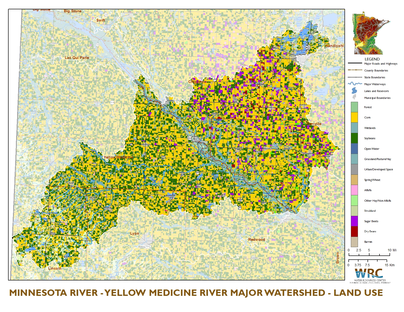
Farmers in the area have a love-hate relationship with the river. It provides drainage, sure, but it’s also a constant threat of erosion. Over the last 50 years, the "flashiness" of the river has increased. When it rains two inches in Canby, the river at the other end of the county rises almost instantly because there isn't enough prairie left to soak up the water. It’s a textbook example of how land-use changes the literal shape of the earth.
Hidden Gems Near the River
If you’re making the trip, don't just stare at the water.
Yellow Medicine County Park is one of those places that mostly locals know about. It’s small, quiet, and has some great hiking trails that get you away from the wind. It’s a prime spot for birdwatching. During the spring migration, the river valley acts as a highway for warblers, hawks, and eagles.
Then there is the Upper Sioux Agency State Park. It’s right at the confluence. Note: As of recently, there have been significant changes regarding the management and land status of this park, with much of the land being returned to the Upper Sioux Community (Pejuhutazizi Kapi). This is a massive deal. It’s a move toward restorative justice and acknowledges that this land is, and always has been, sacred to the Dakota. Before you visit, check current access rules, as some areas may be transitioning to tribal management.
The Conservation Struggle
The Yellow Medicine River MN isn't perfect. It’s plagued by high nitrate levels and sediment. Because the watershed is almost 90% agricultural, whatever goes on the fields eventually ends up in the river.
There’s a lot of work being done by the Yellow Medicine River Watershed District. They’re pushing for more cover crops and buffer strips. It’s a slow process. You can’t just tell a farmer to stop planting on their most productive acres. But the realization is growing: if we don't protect the headwaters, the river—and the Minnesota River it feeds—will just be a glorified drainage ditch. And that would be a tragedy for a waterway with this much history.
Actionable Steps for Your Visit
If you’re planning to check out the Yellow Medicine River, don't just wing it.
- Check the Flow: Hit up the USGS Water Data site. Look for the "Yellow Medicine River near Granite Falls" station. If it’s under 200 CFS, leave the kayak at home and bring your wading boots instead.
- Gear Up: If you’re fishing, heavy-duty gear is a must. 20-pound test line is the minimum if you’re targeting cats. The snags are brutal.
- Respect the Land: Much of the riverbank is private property. In Minnesota, the "water belongs to the people," but the land underneath and beside it often doesn't. Stay in your boat or keep to public access points like the County Park or designated DNR spots.
- Bug Spray: I cannot emphasize this enough. The wood ticks in the tallgrass and the gnats by the water are legendary.
The Yellow Medicine River MN is a place for people who like their nature a little bit raw and a lot bit quiet. It’s not flashy. It doesn't have a gift shop. It’s just a wild, winding piece of the prairie that has managed to hold onto its soul despite everything we’ve built around it. Spend an afternoon on its banks, and you’ll start to hear the stories it’s been trying to tell for centuries.
To get the most out of the area, start your trip in the town of Hanley Falls. Visit the Minnesota Museum of Agriculture to understand the context of the land, then head east toward the river valley as the sun starts to drop. That’s when the light hits the granite outcrops and the river finally looks like the medicine it was named for.