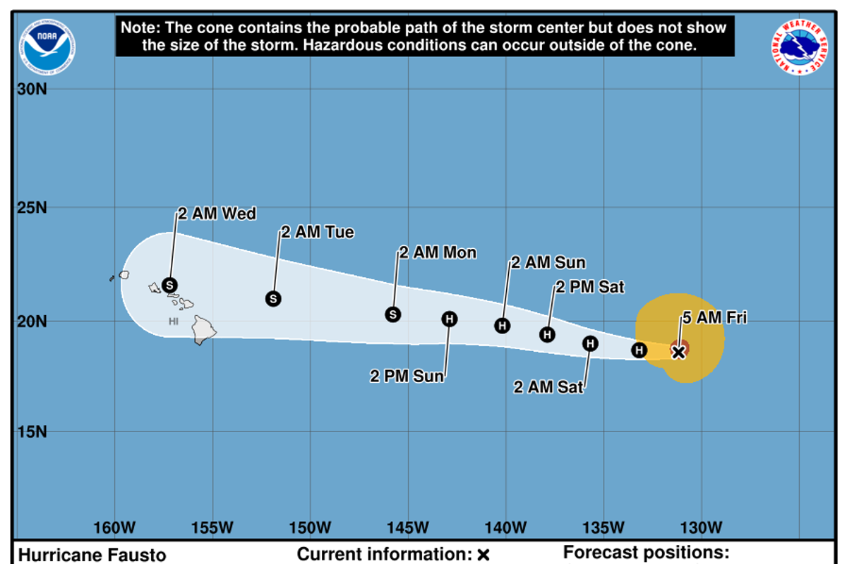
Central Pacific tropical cyclones transitioning to Category 2 intensity represent a specific convergence of thermodynamic and hydrodynamic variables. When a system like Hurricane Fausto intensifies while tracking toward the Hawaiian archipelago, regional infrastructure faces compound stresses that standard wind-scale metrics understate. Evaluating storm hazard requires examining three structural components: thermodynamic intensification drivers, atmospheric steering mechanics, and terrain-induced precipitation amplification.
Thermodynamic Drivers of Mid-Ocean Intensification
The acceleration of a tropical cyclone from Category 1 to Category 2 on the Saffir-Simpson scale demands a sustained extraction of enthalpy from the upper ocean layer. This ocean-atmosphere heat exchange relies on specific threshold conditions in the Central Pacific basin. Building on this theme, you can also read: Targeting Ukrainian Military Ceremonies: The Vulnerability Spectrum of Static Gatherings.
Sea Surface Temperature and Oceanic Heat Content
Sea surface temperatures exceeding 26.5°C supply the latent heat necessary to fuel the cyclonic heat engine. However, surface temperature alone does not dictate sustained intensification. Ocean Heat Content—measured as the integrated thermal energy from the surface down to the 26°C isotherm—determines whether wind-driven vertical mixing brings colder sub-surface water to the top. When Ocean Heat Content remains elevated, sea surface cooling is minimized, maintaining the enthalpy flux into the atmospheric boundary layer.
Atmospheric Stability and Shear Profiles
Tropical cyclogenesis requires low vertical wind shear, defined as the vector difference between upper-level (200 hPa) and lower-level (850 hPa) winds. Shear exceeding 20 knots disrupts the vertical alignment of the storm core, tilting the latent heat release column away from the surface low-pressure center. A low-shear envelope enables deep convection to concentrate around the eyewall, driving rapid barometric pressure drops and upper-level divergence. Experts at The Washington Post have provided expertise on this trend.
Steering Dynamics and Structural Trajectory
The movement of a tropical cyclone toward Hawaii depends on the positioning and strength of the Subtropical High Pressure Ridge. This synoptic-scale pressure feature acts as the primary steering mechanism across the Central Pacific.
- Subtropical High Configuration: A strong, westward-extended subtropical ridge forces a westward trajectory along low-latitude trades, steering the storm directly toward the island chain.
- Trough Interaction: An approaching upper-level trough from the mid-latitudes introduces two competing factors. It can create an inflection point in the steering flow, recurving the storm northward away from the islands, or it can introduce hostile vertical wind shear that degrades the storm's structural core before landfall.
- Translation Velocity: The speed at which the system moves across the ocean dictates exposure duration. Slower translation speeds increase local sea surface mixing (inducing self-weakening) but drastically increase cumulative rainfall totals over land targets.
Topographic Amplification and Infrastructure Risk Mechanics
Standard Saffir-Simpson categorizations measure peak sustained wind speeds, yet wind damage represents only a fraction of total hazard for high-relief volcanic islands. The interaction between cyclone circulation and steep terrain creates localized risk multipliers.
Orographic Precipitation Enhancement
As moisture-laden eyewall and rainband winds encounter steep volcanic topography—such as the slopes of Mauna Kea, Mauna Loa, or Haleakala—forced ascent occurs. This mechanical uplift accelerates adiabatic cooling, accelerating condensation rates and producing extreme localized precipitation. Rainfall rates during topographic forcing often exceed baseline oceanic precipitation models by 200% to 300%, compounding flash flood hazards in narrow drainage basins.
Localized Wind Field Acceleration
Island topography alters wind vector fields through two physical processes:
- Venturi Effect: As cyclonic winds pass through mountain gaps and saddles, cross-sectional area decreases, forcing fluid velocity to increase significantly above synoptic background speeds.
- Downslope Windstorms: Stable atmospheric layers forced over high ridges can produce high-velocity downslope wind events on leeward slopes, creating localized damage zones that exceed the nominal Saffir-Simpson category ratings.
Quantitative Infrastructure Impact Matrix
The physical disruption to island ecosystems and built environments follows distinct threshold mechanics across energy grid, transportation, and agricultural systems.
Grid Stability and Power Distribution
Electrical distribution systems in tropical island environments experience failure through structural pole collapse, vegetation contact, and salt-spray contamination on insulators.
- Category 1 winds (64–82 knots) cause localized radial line failures driven primarily by falling tree limbs.
- Category 2 winds (83–95 knots) exceed the structural design thresholds of standard distribution poles, initiating cascading transmission line failures and widespread grid destabilization.
Hydrological and Agricultural Vulnerability
High precipitation volumes overwhelm municipal drainage channels, driving rapid inundation of coastal lowlands. Simultaneously, wind speeds above 80 knots induce severe mechanical stress on deep-rooted perennial crops and destroy shallow-rooted agricultural production.
Operational Risk Mitigation Framework
Addressing the threat of an approaching Category 2 system requires executing a prioritized sequence of resource allocations based on projected arrival times of tropical-storm-force winds (34 knots).
[T-72 Hours] -> Execute ocean thermal gradient analysis and track error probability framing
[T-48 Hours] -> Stage emergency power assets outside primary inundation and landslide corridors
[T-24 Hours] -> Secure critical drainage bottlenecks and initiate coastal zone access limits
- Resource Staging Strategy: Emergency generation assets and high-clearance rescue equipment must be positioned outside low-lying inundation zones and primary landslide channels prior to the onset of 34-knot winds, after which heavy transport operations become unsafe.
- Drainage Vector Clearing: Pre-storm operations must prioritize clearing debris from high-capacity channels and culverts to prevent artificial damming during peak orographic rainfall events.
- Port and Maritime Management: Harbor operations must mandate vessel sorties or heavy mooring protocols at least 36 hours prior to the arrival of critical swell heights to prevent infrastructure destruction along maritime shipping terminals.
Effective disaster mitigation depends on shifting analytical focus from simplified storm categories to localized hydrodynamic and topographic force mechanics. Emergency management decisions must account for the amplified interactions between high-relief terrain, infrastructural vulnerabilities, and non-linear rainfall dynamics.