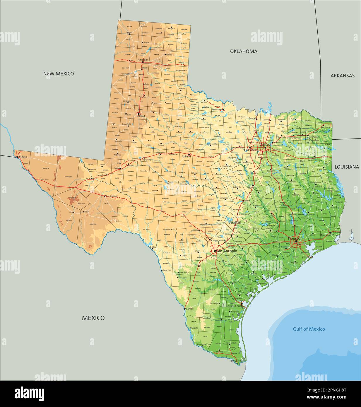
Texas is big. You knew that. But when you actually look at a physical map of Texas, the scale of the transition from the swampy East to the high-desert West is almost hard to wrap your head around. It isn't just one giant flat ranch. Far from it. Honestly, if you drove from Orange to El Paso, you’d climb nearly 4,000 feet in elevation without even hitting the mountains yet. Most people think of the Lone Star State as a monolith of dusty plains, but the geography is actually split into four very distinct provinces.
You've got the Gulf Coastal Plains, the North Central Plains, the Great Plains, and the Basin and Range Province. It’s a lot. If you’re looking at a topographical version, you’ll notice the colors shift from a deep, soggy green in the east to those sharp, craggy browns and purples in the west. This isn't just for aesthetics; it’s a roadmap of how the state was built.
The Soggy Bottoms of the Gulf Coastal Plains
The eastern slice of the state is basically an extension of the deep south. It’s wet. It’s low. If you’re looking at a physical map of Texas, this area is that massive green swath hugging the coastline and stretching deep into the Piney Woods. This region covers about a third of the state. It’s where most of the people live, mostly because that’s where the water is.
Geologists will tell you this area is defined by "cuesta" topography—basically gentle slopes that tilt toward the Gulf of Mexico. You have the Piney Woods up north near Tyler and Longview, which feels more like Georgia than the Wild West. Then you drop down into the Post Oak Savannah and eventually the Blackland Prairie. The soil here is legendary. It’s that thick, "black wax" soil that made cotton king back in the day.
South of that? The Rio Grande Valley. It’s a sub-tropical delta. On a map, it looks like a tiny tip at the bottom, but it’s a massive agricultural engine. The elevation here is negligible. You’re talking maybe 0 to 500 feet above sea level. It’s flat, humid, and holds the drainage for almost every major river in the state.
Where the Balcones Escarpment Changes Everything
If you’re driving west from Austin or San Antonio, you’ll hit a sudden rise. That’s the Balcones Escarpment. It is arguably the most important feature on any physical map of Texas. This is a fault zone. It’s the literal "line in the sand" where the low coastal plains end and the rugged uplands begin.
The Hill Country Magic
This is the Edwards Plateau. People call it the Hill Country, but geologically, it’s a uplifted limestone plateau that has been carved out by thousands of years of water erosion. It’s why we have so many caves. The Barton Springs in Austin or the Comal River in New Braunfels? Those exist because of this specific physical transition. The limestone acts like a giant sponge—the Edwards Aquifer—which is one of the most productive artesian aquifers in the world.
On a map, this looks like a rugged, pockmarked heart in the center of the state. It’s not great for farming because the soil is thin and rocky, but it’s incredible for scenery. You’ll notice the "Llano Uplift" right in the middle of this area. That’s where you find Enchanted Rock. It’s a massive pink granite dome that is actually much older than the limestone surrounding it. It’s a "pluton," an igneous rock that cooled underground and was eventually uncovered. It’s a weird anomaly that stands out on any high-detail geological map.
The High Plains and the Llano Estacado
Move further north and west, and things get flat. Really flat. This is the Great Plains. But don't let the flatness fool you; the elevation is climbing fast. By the time you get to Amarillo, you’re at 3,600 feet.
The standout feature here is the Llano Estacado, or the "Staked Plains." It is one of the largest tablelands in North America. Legends say early Spanish explorers had to drive stakes into the ground just to find their way back because there were no landmarks—no trees, no hills, nothing. Just horizon.
Palo Duro Canyon: The Big Tear
Right in the middle of that flatness is a giant gash: Palo Duro Canyon. It’s the second-largest canyon in the United States. If you’re looking at a physical map of Texas, look for a jagged red line south of Amarillo. That’s the Red River carving its way through the Caprock Escarpment. The contrast is wild. You’re driving across a pancake-flat wheat field, and suddenly the earth just drops away into 800 feet of red clay and yellow stone.
The Caprock Escarpment is the boundary. It’s a steep cliffside that separates the High Plains from the lower Rolling Plains to the east. It’s a brutal, beautiful piece of geography that defines the "Panhandle" identity.
Mountains in Texas? The Trans-Pecos Reality
The biggest misconception about Texas geography is that we don't have real mountains. Tell that to someone in Brewster County. The Trans-Pecos region, located west of the Pecos River, is part of the Basin and Range Province. This is the same geological family as the Rocky Mountains.
You’ve got over 150 peaks that soar above a mile high. Guadalupe Peak is the king at 8,751 feet. On a map, this area is a mess of dark browns and high-contrast ridges.
- The Davis Mountains: Formed by volcanic activity. These are "sky islands" where the altitude makes it cool enough for Ponderosa pines to grow in the middle of a desert.
- The Chisos Mountains: Located inside Big Bend National Park. This is the only mountain range in the U.S. contained entirely within a single national park.
- The Franklin Mountains: They literally split the city of El Paso in half.
This region is rugged. It's dry. It's the northern reach of the Chihuahuan Desert. The Rio Grande snakes through here, carving deep canyons like Santa Elena, where the limestone walls rise 1,500 feet straight up from the water.
Why the Rivers All Run Southeast
Take a close look at the blue lines on a physical map of Texas. Notice something? Almost every single one of them—the Brazos, the Colorado, the Trinity, the Guadalupe—runs from the northwest to the southeast.
Texas is tilted.
The entire state is basically a giant ramp leaning toward the Gulf of Mexico. This is why the state has such a huge "drainage" issue. When it rains in the Hill Country, all that water gathers speed as it slides down the Balcones Escarpment toward the coast. It’s why Central Texas is the "Flash Flood Alley" of the world. The physical geography dictates the danger.
The Practical Side of the Map
Understanding the physical layout of Texas isn't just for hikers or geologists. It explains why the economy looks the way it does.
- Wind Power: Those flat, high-elevation plains in the Panhandle? That’s why Texas leads the country in wind energy. The wind doesn't have anything to hit, so it just hauls.
- Oil and Gas: The Permian Basin in the west is a literal bowl filled with ancient organic matter. Its physical shape and geological history are the reason for the massive energy production in Midland and Odessa.
- Agriculture: You can’t grow citrus in the Panhandle, and you can’t easily graze cattle in the dense Piney Woods. The map tells the farmers what to do.
Actionable Insights for Your Next Trip
If you’re planning to explore Texas based on its physical geography, don't try to do it all at once. It’s too big. Instead, pick a "transition zone" to witness the change in terrain.
- The Caprock Drive: Take Highway 207 south from Claude. You’ll drop off the Llano Estacado into the Palo Duro system. It’s the most dramatic elevation change you can see from a car in the state.
- The Hill Country Loop: Base yourself in Fredericksburg and head toward Willow City Loop. You’ll see the limestone of the Edwards Plateau give way to the ancient granite of the Llano Uplift.
- The Big Bend Reach: If you want the mountains, you have to commit. It’s an 8-hour drive from nearly anywhere, but standing at the South Rim looking into Mexico is the only way to appreciate the Basin and Range province.
Check the weather. The physical map of Texas creates its own microclimates. It can be 75 degrees in Brownsville and snowing in Dalhart on the exact same day. That 800-mile stretch covers a lot of vertical and horizontal ground.
When you look at the map next time, don't just look for the cities. Look for the "balcones," the "escarpments," and the "plateaus." That’s where the real story of the state is written. The roads just follow the path the rocks allowed them to take.
To get the most out of a physical study of the state, grab a high-resolution topographical map from the Texas Bureau of Economic Geology. They have detailed sheets that show the specific rock types, which explain exactly why certain areas have caves, why some have red dirt, and why others are nothing but sand and scrub. Explore the state by its layers, not just its highways.


