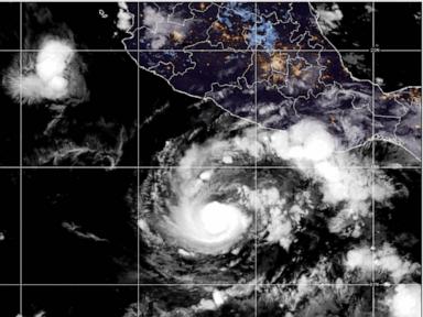
When Hurricane Trudy churned off Mexico's Pacific coast in mid-October 2026, headline readers focused on wind speed and storm category. That's the wrong thing to obsess over first. On steep coastal terrain where soils are already soaked, water does the real damage.
I've watched plenty of coastal residents and travelers misread a storm like Trudy because they wait for a direct landfall warning before taking action. A hurricane doesn't have to slam straight through your town to wreck your weekend, flood your street, or trigger a mudslide on a hillside. Even when a system tracks roughly parallel to the shore and weakens before making a clean central hit, heavy rain bands and long-period ocean swells reach far beyond the eye.
Why Hurricane Trudy Caught Attention Along the Pacific Coast
Trudy didn't pop up out of nowhere or sit quietly in open water. After organizing in the eastern Pacific in early-to-mid October 2026, it gained hurricane strength and briefly spiked as high as Category 3 intensity on October 16 before fluctuating and moving northwestward near southwestern and west-central Mexico. Forecasters at the U.S. National Hurricane Center tracked its approach alongside Mexico's Servicio Meteorológico Nacional (SMN), issuing hurricane and tropical storm watches and warnings stretching across key coastal corridors from Guerrero through Michoacán, Colima, and Jalisco.
Timing made the setup nastier. Trudy arrived right on the heels of Hurricane Simon, which had already battered parts of the same coastline just days earlier. When one storm wets the ground and a second follows within a week, soil moisture doesn't reset overnight. Rain that might normally soak in—or drain gradually through culverts and arroyos—runs off fast.
A slow-moving or coast-hugging tropical system can dump heavy rain over the same mountain-backed valleys for hours, turning dry streambeds into flash-flood channels long before peak winds arrive.
Look at how quickly intensity shifted during Trudy's run. A storm can intensify rapidly over warm Pacific waters, hit Category 2 or Category 3 strength, and then lose punch as it interacts with rough coastal topography or encounters stronger upper-level wind shear. That roller coaster frustrates people watching a single number on a screen. One advisory sounds alarming; the next sounds calmer. Yet the rain shield often stays wide and stubborn even as maximum sustained winds drop.
Rain, Mudslides, and Rough Surf Matter More Than Peak Winds
Ask anyone who's lived near Mexico's western shore during autumn cyclone season what scares them most. Usually, it isn't a brief gust at the beach. It's water coming off the hills and water coming up from the sea.
Along the coasts of Michoacán, Colima, and Jalisco, forecasters warned of widespread rainfall totals in the 4 to 8 inch range over the weekend, with isolated pockets capable of reaching around 12 to 15 inches. Outer bands also pushed meaningful rain toward Guerrero and Nayarit. Where rugged mountains drop sharply toward narrow coastal plains, runoff concentrates fast. Mudslides and flash flooding don't care whether the storm's center is 100 miles offshore or 20.
Then there's the ocean itself. Even without a bullseye landfall in a given resort city, long-period swells push ahead of and around a tropical cyclone. In places like Acapulco, fishermen have long known the drill: pull small boats out of the water early when heavy swells and shifting conditions threaten harbors and coves. Rip currents and heavy surf turn calm-looking beaches into traps fast.
Here's a misconception that trips people up every single season: if the wind isn't roaring at my hotel window, the storm isn't really hitting us.
Honestly, that's backwards. Plenty of serious disruption happens on the "quiet" side of a wind forecast. Clogged storm drains flood low streets. Unpaved roads wash out. Rivers swell hours after the hardest downpour passes inland. If you judge risk solely by the Saffir-Simpson wind scale, you're ignoring the two biggest killers in tropical cyclones—freshwater flooding and ocean swells.
How Coastal Hubs Like Puerto Vallarta, Manzanillo, and Acapulco Experience a Storm
Geography splits Mexico's Pacific coast into distinct micro-environments, and Trudy showed why a regional warning doesn't hit every city the same way.
Take Puerto Vallarta in Jalisco. When a hurricane warning is posted farther south—such as between Manzanillo and Cabo Corrientes—Puerto Vallarta may sit under a tropical storm warning or watch rather than a direct hurricane bullseye. That doesn't mean business as usual. Heavy rain still threatens hillside neighborhoods, steep streets, and low-lying drainage routes, and flights into regional airports can face delays or schedule adjustments when squalls and shifting winds move through. After Hurricane Simon disrupted flights earlier in October 2026, travelers and aviation planners were already hyper-aware of how quickly schedules unravel.
Farther south, Manzanillo in Colima and coastal stretches of Michoacán face both marine exposure and steep inland terrain. Ports and coastal shipping feel deteriorating seas well ahead of the core, while local Civil Protection teams watch saturated soils and drainage bottlenecks. Meanwhile, Guerrero—including Acapulco and Zihuatanejo—can get soaked and churned by outer rain bands and swells even when the main warning zone shifts northwestward.
One practical detail experts and property managers emphasize time and again: wind-borne debris and water intrusion usually happen through weak points, not whole walls collapsing. Unsecured patio furniture, open or poorly sealed sliding glass doors, and clogged roof drains cause a huge share of avoidable property headaches.
What Forecasters Watch That Casual Readers Skip
Meteorologists don't just look at where a storm is right now. They look at what's steering it, what's shearing it, and how fast it's moving.
A slow-moving storm is often worse for rain totals than a fast one. When a system crawls at 5 to 7 mph near the coast, coastal communities sit under heavy moisture feed longer. Conversely, when upper-level winds increase or a storm brushes mountainous terrain, its core can get disrupted and weaken faster than people expect. That's why forecast uncertainty matters. Two runs of a computer model can differ sharply on exact landfall timing or whether a storm stays offshore or clips a headland.
There's also a real limitation in weather reporting that deserves plain honesty: exact rainfall totals at any single neighborhood level are notoriously hard to pin down days ahead. Convective rain bands pack intense downpours into narrow strips. One block gets flooded; two miles away gets a breezy drizzle. Anyone promising exact street-by-street impacts 72 hours out is guessing.
Practical Steps If You Live, Own Property, or Travel on the Coast
If you're planning a trip along Mexico's Pacific coast during hurricane season—or managing a home or rental there—don't rely on last-minute improvisation. Do the unglamorous prep early.
- Check official advisories, not viral social clips. Follow the National Hurricane Center, Mexico's SMN, and state or municipal Civil Protection (Protección Civil) updates. Social posts strip context and recycle old photos.
- Build buffer days into coastal travel. If you're flying through hubs like Puerto Vallarta, Manzanillo, or nearby Pacific airports during active October weather, keep flexible tickets and avoid tight same-day connections.
- Clear drainage and secure outdoor gear before rain starts. Clean gutters, yard drains, and balconies ahead of wet weather, and bring in loose chairs, umbrellas, and planters before gusts pick up.
- Never drive or walk through moving floodwater. A few inches of fast runoff on a coastal road can hide washed-out pavement or sweep a vehicle off course. Wait out heavy downpours in sturdy shelter.
- Respect beach and harbor closures. Red flags, port restrictions, and rough surf warnings exist because rip currents and sneaker waves don't care about your vacation schedule.


