The air inside the concrete apartment block smells like baked dust and desperate electricity. For six days, Elena has kept her windows shut against the shimmering haze of a city trapped in a high-pressure dome. Her window unit AC—a boxy, rattling machine from the late nineties—has been screaming a high-pitched metallic note since Tuesday. It is losing the battle. The air coming out of the vents is no longer crisp; it is lukewarm, like a sigh. Elena presses a cold, sweating can of seltzer against the inside of her wrist. She checks the weather app on her phone for the fourth time in an hour.
A blue arrow has appeared on the digital map. A cold front is moving in from the northwest. By Tuesday night, the app promises, the temperature will drop by fifteen degrees. Meanwhile, you can explore similar developments here: The Geopolitics of State Memory Deconstructing Israels Armenian Genocide Resolution.
Tens of millions of people across the region are looking at that same blue arrow. In office buildings where the HVAC systems have been working overtime, in farming communities where the topsoil is turning to powder, and in tiny apartments like Elena’s, the collective sigh of relief is almost audible. The heatwave is breaking. The monster is retreating.
Except it isn't. Not really. To understand the complete picture, check out the detailed article by NBC News.
What we are about to experience this week is a meteorological magic trick. It is a brief, deceptive pause in a seasonal pattern that is becoming increasingly relentless. The cold front arrives with a dramatic flourish of wind and perhaps a scattering of thunderstorms, but it carries a hidden truth: the relief is a ghost. Within forty-eight hours of its arrival, the atmospheric machinery will shift again, locking us back into the furnace. To understand why this temporary reprieve is actually a warning sign, we have to look beneath the surface of the daily forecast.
The Physics of a Temporary Truce
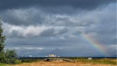
A cold front sounds like a rescue party. In reality, it is a collision.
Think of the atmosphere right now as a massive, heavy blanket of warm, humid air that has settled over the concrete and asphalt of our cities. Because cities act as heat islands—absorbing solar radiation during the day and radiating it back out at night—this air mass becomes incredibly stable. It doesn't want to move. To displace it, you need a massive wedge of denser, cooler air to slide underneath it, lifting the warm air upward like a shovel lifting dirt.
When that wedge arrives this week, the immediate result will feel miraculous. The thermometer will plummet from the mid-nineties down to a manageable seventy-eight degrees. You will open your windows. You will turn off the air conditioning. The ambient hum of the neighborhood will change as hundreds of compressors finally fall silent.
But look at the broader map. The jet stream—the high-altitude river of air that dictates our weather patterns—is behaving erratically. Instead of moving in a smooth, predictable wave from west to east, it is looping into deep, jagged bends. This particular cold front is being pushed by a minor ripple in that stream. It is a transient visitor, a weak pulse of northern air that lacks the stamina to stick around.
Behind this brief cold wedge lies a massive, high-pressure ridge building over the western plains. Meteorologists call this a heat dome. It is essentially an atmospheric pressure cooker. As high pressure sinks, it compresses the air beneath it. Compression breeds heat. This ridge is already migrating eastward, trailing directly behind our brief taste of autumn. The moment the northern wind dies down, the dome will slide into place, trapping the sun's energy and baking the ground all over again.
The transition back to extreme heat will be faster than the descent into comfort. By Friday afternoon, the humidity will creep back into the valleys. By Saturday, the asphalt will be radiating heat long after sundown.
The Human Toll of the Rollercoaster
The danger of a short-lived cold front is not just that the heat returns; it is how the sudden shift affects the human body and our shared infrastructure.
When extreme heat is continuous, people adapt. They adjust their routines. They stay indoors, they check on vulnerable neighbors, and city municipalities keep cooling centers open. There is a baseline of survival logic that sets in during a prolonged emergency.
A sharp, temporary drop in temperature shatters that vigilance.
Consider the physiological strain of the atmospheric seesaw. The human body regulates temperature through a complex dance of cardiovascular expansion and sweat production. When the air cools down for forty-eight hours, your blood vessels constrict, your heart rate stabilizes, and your body signals that the crisis has passed. Then, forty-eight hours later, the heat returns with a vengeance. This rapid cycling is incredibly taxing on the elderly and those with chronic respiratory conditions. The body is forced to re-acclimatize twice in less than a week.
On a larger scale, our infrastructure experiences a similar whiplash.
During the peak of a heatwave, power grids operate under a state of managed tension. Energy companies monitor load thresholds closely. When the temperature drops, demand plunges. Power plants use this window to perform emergency maintenance on strained transformers and grid components. However, a two-day window is barely enough time for the physical hardware to cool down, let alone undergo meaningful repair. When the heat dome re-establishes itself on Friday, the grid is slammed with a sudden, massive spike in demand as millions of air conditioners kick back on simultaneously. It is the atmospheric equivalent of slamming on the brakes of a speeding car and then immediately stomping on the gas.
The Changing Shape of Summer
We used to talk about summer in terms of averages. A hot week here, a rainy patch there, balancing out to a predictable seasonal norm. That version of the climate is fading from memory.
What we are seeing now is a pattern of amplification. The highs are higher, the shifts are more violent, and the periods of relief are shrinking into smaller and smaller windows. A decade ago, a cold front in July might have cleared the air for a week or more, allowing the soil to retain moisture and giving the flora time to recover. Now, these fronts act more like a brief gasping for air before being pushed back underwater.
Elena’s apartment will cool down on Wednesday morning. She will leave her windows open to catch the northern breeze, feeling a sense of renewal that always accompanies the end of a oppressive heatwave. She will buy groceries without dreading the walk back from the store.
But by Friday morning, the air will turn stagnant again. The sky will lose its deep blue tint, fading into that familiar, milky white haze that signals high-pressure compression. The boxy window unit will rattle back to life, its ancient motor straining against the rising tide of a summer that refuses to let go.
The blue arrow on the weather app is not a savior. It is a intermission. Enjoy the cool air while it lasts this week, but do not mistake it for a change in the season. The dome is already waiting at the border.