The sheer scale of Iguazu Falls defies standard geographical categorization. While most observers focus on the aesthetic beauty of the 2.7-kilometer-wide basalt rim, the reality of this site is rooted in a violent hydraulic engine that moves up to 45,000 cubic meters of water per second during peak floods. This isn't just a scenic border between Brazil and Argentina. It is a massive, shifting monument to the tectonic instability of the Paraná Basin and a focal point for regional energy security that pits environmental preservation against the industrial demands of South America’s largest economies.
Most travel reports gloss over the technical brutality of the "Devil’s Throat." They describe the mist and the rainbows. They ignore the fact that this waterfall system is a geological anomaly that has been retreating upstream for thousands of years, carving a deep canyon through the earth like a slow-motion buzzsaw. To understand Iguazu, you have to look past the postcards and examine the infrastructure, the politics of the water flow, and the precarious balance of an ecosystem that is currently being strangled by upstream damming.
The Engineering of a Natural Wonder
The Iguazu Falls are not a single drop but a collection of nearly 275 individual cataracts. The layout is a horseshoe-shaped fracture in the earth. The geology here is dominated by the Serra Geral formation, a massive layer of flood basalt that formed 130 million years ago. These are some of the hardest rocks on the planet, yet the sheer force of the Iguazu River has managed to split them open.
The mechanics of the falls are governed by the intersection of two major river systems. The Iguazu River flows westward across a high plateau before plummeting over the edge of the plateau into the Paraná River. This creates a "knickpoint"—a sharp change in channel slope. Unlike Niagara, which has a relatively consistent flow regulated by the Great Lakes, Iguazu is volatile. It is a rain-fed beast. In periods of drought, the falls can dwindle to a trickle, revealing the jagged black ribs of the basalt. In periods of heavy rain, the individual falls merge into a single, terrifying wall of brown water that obliterates everything in its path.
The Upstream Stranglehold
If you want to know who really controls Iguazu Falls, don't look at the park rangers. Look at the engineers. Brazil operates a series of six major hydroelectric dams on the Iguazu River before it ever reaches the park. These aren't small operations. They are massive industrial batteries that power cities like Curitiba and São Paulo.
The impact on the falls is profound.
- Flow Regulation: The dams can effectively "turn off" the falls or create artificial floods based on power demand and reservoir levels.
- Sediment Trapping: Dams stop the natural flow of silt, which starves the downstream river of the nutrients needed to maintain the riverbanks.
- Ecological Disruption: The seasonal pulse of the river, which the local flora and fauna have adapted to over millennia, is now dictated by an electrical grid.
When tourists complain that the falls look "thin," it is rarely a natural weather event. It is usually the result of upstream management prioritizing the grid over the view. Argentina, which holds about 80% of the falls' physical territory, often finds itself at the mercy of Brazilian water management policies. It is a quiet, ongoing diplomatic friction point that rarely makes the headlines.
The Sovereignty of the Mist
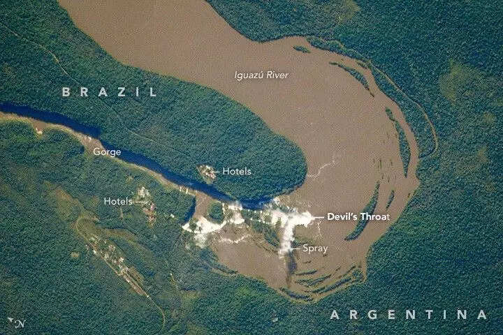
The border between Brazil and Argentina runs straight through the Devil’s Throat. This is the deepest and most powerful section of the falls. Standing on the Argentinian side, you are practically inside the spray, looking down into the abyss. On the Brazilian side, you get the panoramic perspective, seeing the full 2.7-kilometer width in one frame.
This division isn't just for map-makers. It defines the entire economic model of the region. Argentina has invested heavily in a network of ecological trains and low-impact walkways that snake through the jungle, emphasizing a "nature-first" approach. Brazil, conversely, has leaned into high-capacity infrastructure, including elevators and expansive viewing platforms that cater to massive tour groups.
Both nations are locked in a struggle to monetize the site without destroying the very environment that attracts the capital. The surrounding Atlantic Forest is one of the most endangered biomes on earth. Only about 7% of its original cover remains. The national parks on both sides of the falls act as a final fortress for jaguars, giant otters, and the elusive harpy eagle. But even a fortress can be breached by the sheer volume of human traffic.
The Tourism Paradox
There is a specific kind of arrogance in modern travel that treats a site like Iguazu as a backdrop for a digital profile. The parks receive millions of visitors annually. This creates a massive carbon footprint and physical stress on the trails.
- Helicopter Overflights: For years, Brazil allowed helicopter tours over the falls. Argentina banned them, citing the acoustic trauma to the bird populations. This remains a point of contention between the two nations' environmental ministries.
- Water Contamination: The rapid development of the gateway cities—Foz do Iguaçu and Puerto Iguazú—has put immense pressure on local sewage and waste management systems.
- Invasive Species: The constant movement of people brings in seeds and small organisms that threaten the delicate balance of the subtropical rainforest.
The "largest waterfall system" is also a massive target for commercial exploitation. There is constant pressure to build more hotels closer to the rim, to expand the airports, and to increase the frequency of high-speed boat tours that take tourists directly into the spray of the San Martin fall.
The Geological Inevitability of Collapse
Geology doesn't care about national borders or tourist revenue. The falls are in a constant state of retreat. Every second, the water erodes the softer sedimentary rock layers beneath the basalt cap. Eventually, the cap loses its support and collapses into the canyon below.
Historically, the falls were located several kilometers downstream at the confluence with the Paraná River. Over thousands of years, they have marched backward to their current position. This process is accelerating. Human-induced climate change is creating more extreme weather patterns in the Rio de la Plata basin. We are seeing more frequent "thousand-year floods" and deeper, longer droughts.
When the flow hits its peak—like it did in 2022 when the volume reached sixteen times the average—the infrastructure itself is at risk. Walkways are regularly ripped from their moorings and tossed into the gorge. The engineering required to keep the site accessible to humans is becoming increasingly expensive and complex. We are fighting a losing battle against the river's desire to level the plateau.
The Myth of the "Greatest" Fall
Comparison is the thief of appreciation, but in geography, it’s a tool for understanding scale. Victoria Falls in Africa is taller. Angel Falls in Venezuela has a longer single drop. But Iguazu wins on complexity. It is a fragmented, chaotic system that changes its shape every hour.
The 2.7-kilometer width is a staggering number, but it is the volume of those 275 individual curtains of water that creates the sensory overload. The sound isn't a roar; it is a physical vibration that you feel in your chest. It is the sound of the earth being dismantled.
The Economic Engine of the Borderlands
The Tri-Border Area, where Brazil, Argentina, and Paraguay meet just a few miles from the falls, is one of the most unique economic zones in the world. While the falls provide the "green" tourism revenue, the nearby Itaipu Dam provides the "black" industrial power.
Itaipu was, until recently, the largest hydroelectric plant in the world by generation. It is a binational project between Brazil and Paraguay. The proximity of such a massive industrial achievement to such a massive natural wonder creates a jarring contrast. One is a monument to human engineering; the other is a monument to natural force.
The economy here is a strange mix of:
- High-End Hospitality: Luxury lodges that charge thousands of dollars a night for a view of the jungle canopy.
- Duty-Free Trade: The city of Ciudad del Este in Paraguay is a chaotic hub of electronics and consumer goods, fueled by the porous borders.
- Scientific Research: Biologists from around the world converge here to study the intersection of tropical and subtropical climates.
This isn't just a park. It’s a multi-billion dollar machine. The falls are the "anchor tenant" for a massive regional economy that supports millions of people. If the water stops flowing, or if the ecosystem collapses, the entire region goes bankrupt.
The Shadow of Climate Instability
The future of Iguazu Falls is tied directly to the health of the Amazon rainforest. Much of the rain that feeds the Iguazu River is generated by the "aerial rivers" of the Amazon—massive plumes of water vapor released by trees that travel south. As deforestation in the north continues, the moisture supply for the south is becoming unpredictable.
If the Amazon reaches a tipping point, the Iguazu Falls could become a seasonal relic. We are already seeing the warning signs. The record droughts of the last decade have forced the shutdown of hydroelectric turbines and reduced the falls to a series of pathetic trickles. This isn't just bad for photos; it is a systemic failure of the regional water cycle.
Survival in the Spray
Despite the human interference, the sheer power of the site remains its defining characteristic. The swifts—small birds that nest directly behind the falling water—are a testament to the resilience of life here. They fly directly through the wall of water to reach their nests, using the falls as a shield against predators.
Humans have tried to replicate this sense of invulnerability with concrete and steel. We build catwalks that we hope will withstand the next flood. We build dams that we hope will control the flow. But stand at the edge of the Devil's Throat for five minutes, and you realize how fragile those efforts are. The mist is corrosive. The vibration is relentless. The river is moving more than just water; it is moving the very foundation of the continent.
The next time you look at a map of South America, don't just see the line between Brazil and Argentina. See the fracture. See the 2.7 kilometers of falling water as a warning that we do not "manage" nature. We merely negotiate with it, and the river always has the final say in the negotiations.
The maintenance of the walkways is a constant, losing game against the elements. Every decade, the maps must be updated as the basalt gives way. The "largest waterfall system" is a living, breathing, and dying entity. It is an industrial powerhouse and a fragile sanctuary. It is a border and a bridge.
Stop treating it like a destination. Treat it like a deadline. The forces that created this 130 million years ago are the same forces that will eventually level it. The only question is whether our infrastructure and our political agreements will survive the transition.
Pack your waterproof gear, but leave the illusions at home. You aren't going to see a park; you are going to witness a geological demolition in real-time. Respect the volume. Fear the flood.
If you are planning a visit, start by monitoring the flow rates through the Brazilian National Agency of Waters (ANA). Watching the live data is the only way to know if you’re seeing the falls at their intended power or if you’re looking at a version heavily edited by the upstream dam operators.


