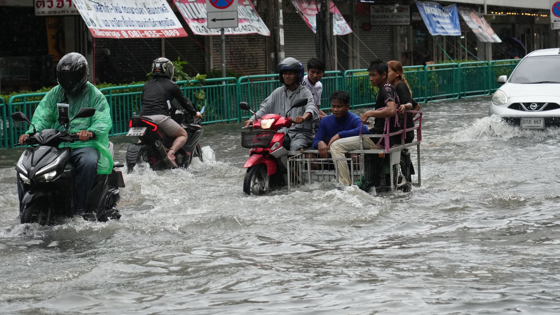
When the capital of Thailand was officially designated a disaster zone following a deluge of more than thirty centimeters of rain within forty-eight hours, international media framed it as an act of meteorological fury. Tropical downpours are a staple of Southeast Asian monsoons, and the sheer volume of water was undeniably staggering. Yet blaming the clouds misses the structural reality of a metropolis built on shifting mud, strangled by concrete, and governed by short-term political expediency. The water did not arrive as an unpredictable anomaly. It arrived in a landscape engineered to trap it.
To understand why a major urban center paralyses under heavy rain, one must look below the asphalt. Bangkok sits on the Chao Phraya River delta, a vast basin of soft, compressible clay sediment. For decades, the city's exponential growth relied on intensive groundwater pumping to feed factories, high-rise developments, and millions of residents. Extracting subterranean water acted like pulling the plug on a wet sponge. The underlying soil compacted, causing the ground level to drop by several centimeters annually during the peak of industrial expansion.
While heavy restrictions on groundwater extraction were eventually enacted, slowing the rate of descent, the damage was already locked into the geology. Large swaths of the metropolitan area now rest below sea level, defended from the adjacent Gulf of Thailand by earthen dykes, concrete walls, and massive drainage tunnels. When torrential rain hits a bowl-shaped basin where the rim is higher than the interior, gravity ceases to be an ally. Rainwater cannot simply flow out toward the sea on its own accord. It must be mechanically lifted and pushed uphill, creating a system where a single mechanical failure at a pumping station can turn a neighborhood into an aquatic trap.
The geography of water management in this delta was once remarkably sophisticated. Historically known as the Venice of the East, the city functioned as an intricate web of natural distributaries and hand-dug canals known locally as khlongs. These waterways served a dual purpose. They provided transport and commerce, while acting as massive retention basins that absorbed seasonal floodwaters and safely channeled them into the sea.
Modern urban planning systematically dismantled this natural defense. Over the last half-century, thousands of kilometers of canals were paved over, filled in, or narrowed to make way for roads, shophouses, and commercial real estate. Water needs space. When you replace absorbent earth and open channels with impermeable concrete, you eliminate the ecosystem's capacity to buffer extreme weather events.
During the recent downpour, runoff coefficients spiked dramatically. Rainwater hit roofs, parking lots, and multi-lane highways, finding nowhere to soak in. It rushed instantly into drainage pipes that were engineered decades ago for a lower population density and vastly different precipitation patterns. The infrastructure was overwhelmed long before the storm reached its peak intensity. Water backed up through storm drains, bubbled out of manholes, and pooled in low-lying intersections, paralyzing traffic arteries and trapping commuters in vehicles for hours.
The architectural boom reshaping the skyline introduces another overlooked variable. Mega-projects, luxury condominiums, and massive shopping malls do not just replace green spaces; they add immense dead weight to an already unstable clay foundation. Each skyscraper exerts downward pressure, accelerating localized settling. Furthermore, these massive developments frequently alter local drainage patterns. Private construction projects routinely raise their foundational land levels above the surrounding street grade to protect their own investments. Water, obeying the laws of physics, flows off these elevated artificial islands and pools directly onto neighboring public roads and working-class residential quarters that lack the capital to elevate their properties.
This dynamic exposes a stark socioeconomic divide in how urban crises unfold. Wealthier districts feature advanced retention systems, private pumps, and elevated infrastructure that keep the water at bay. Meanwhile, informal settlements and older neighborhoods built in low-lying depressions bear the brunt of the overflow. These communities experience prolonged stagnation, where floodwaters mix with runoff from industrial sites and overloaded sanitation systems, creating severe health hazards that linger days after the rain stops falling.
Governance structures compound the physical vulnerability. Bangkok operates under a complex matrix of administrative responsibilities divided between the city administration, national government ministries, and various specialized departments. When disaster strikes, jurisdictional friction often stalls emergency response. The city governor may order pumps activated, but provincial authorities control upstream retention gates. National agencies manage major waterways, while municipal workers clear neighborhood drains. Bureaucratic hand-wringing during a crisis transforms manageable drainage bottlenecks into systemic gridlock.
Climate change acts as a force multiplier across this fragile intersection of geography and planning. Rising global temperatures increase the atmosphere's capacity to hold moisture, resulting in shorter, more violent cloudbursts. Sea levels in the Gulf of Thailand are creeping upward, narrowing the window during high tides when gravity drainage is even theoretically possible. When a torrential rainstorm coincides with an unusually high astronomical tide, the river gates cannot be opened without risking catastrophic backflow from the sea. The city finds itself trapped between rising tides at the coast and trapped runoff from the interior.
Engineers and urban planners have proposed ambitious countermeasures. Proposals include underground stormwater retention caverns, expanded drainage tunnels, and the creation of public parks designed to double as seasonal retention basins during monsoons. Some districts have experimented with smart drainage systems equipped with real-time sensors that automatically adjust pump operations based on water pressure and volume.
Yet these technological fixes often serve as costly band-aids on a deeper wound. Building deeper tunnels and higher walls treats the symptom while ignoring the root cause of urban overdevelopment and poor spatial planning. As long as land use policies prioritize short-term commercial returns over hydrological common sense, engineering marvels will struggle to keep pace with environmental reality.
The disaster designation given to the capital following the recent storm should not be viewed as an extraordinary tragedy brought on by an angry sky. It is a predictable milestone in the history of a city that chose to concrete over its own defense mechanisms. Every monsoon season will test the limits of these temporary safeguards, and every storm will expose the fractures beneath the asphalt.
The water recedes eventually, leaving behind slick mud, damaged property, and exhausted residents trying to salvage what remains. But the fundamental imbalances in the delta remain unresolved. The rain will return, the ground will continue to compact, and the city will face the same rising tide with the same inadequate tools.