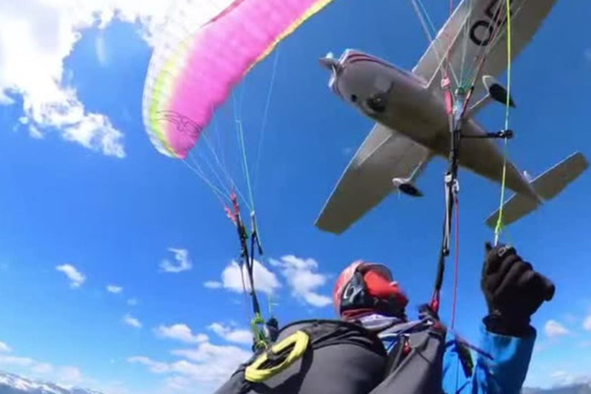
A mid-air collision between a non-motorized paraglider and a motorized aircraft over the Austrian Alps isolates a critical systemic failure in contemporary airspace management: the dangerous convergence of commercial, recreational, and unpowered aviation within complex topographical environments. This incident cannot be dismissed as a statistical anomaly or a freak accident. Instead, it serves as a case study for the breakdown of visual separation rules, structural flaws in integrated transponder networks, and the acute thermodynamic realities of alpine aviation.
To prevent catastrophic outcomes in shared airspace, aviation authorities and recreational pilots must move beyond the reliance on see-and-avoid principles. Mitigating these risks requires an understanding of how geographic bottlenecks, divergent kinetic profiles, and technical asymmetry compromise safety margins.
The Tri-Axiom Risk Matrix of Mixed-Use Airspace
The interaction between a light aircraft and a paraglider exposes an operational friction point governed by three distinct structural variables. When these variables intersect, the probability of a critical conflict escalates exponentially.
1. Velocity Asymmetry and Visual Acquisition Latency
The primary operational failure in mixed-use airspace stems from the stark disparity in closure rates between motorized aircraft and unpowered foot-launched gliders.
- The Light Aircraft Profile: Operating under Visual Flight Rules (VFR), a standard single-engine light aircraft (such as a Cessna 172 or Diamond DA40) maintains a cruise speed between 100 and 130 knots ($approx 185\text{ to }240\text{ km/h}$).
- The Paraglider Profile: A modern intermediate paraglider operates within a narrow trim speed window of 20 to 25 knots ($approx 35\text{ to }45\text{ km/h}$), with a maximum speed rarely exceeding 32 knots ($60\text{ km/h}$) under full acceleration.
This kinetic imbalance compromises the traditional See-and-Avoid doctrine. A light aircraft closing in on a paraglider from behind or at an oblique angle creates a closing speed of over 50 meters per second. Because a paraglider presents a minimal frontal cross-section—often reduced to a thin silhouette when viewed edge-on—the motorized pilot’s visual acquisition window drops below the human physiological reaction threshold. By the time a paraglider enters the scanning field of a pilot traveling at 120 knots, the time remaining to execute an evasive maneuver is frequently less than three seconds.
2. Orographic Obstacles and Flight Path Confinement
The geography of the Austrian Alps acts as a physical funnel that forces disparate aircraft types into the same narrow corridors.
[Alpine Ridge Line]
     │
     ├──> Strong Thermals / Updrafts (Paraglider Operational Zone)
     │
     └──> Narrow Valley Floor / Transit Corridor (Light Aircraft Path)
Alpine topography restricts flight paths in two ways:
- Vertical Compression: High mountain peaks force light aircraft to fly through low valley passes or follow specific terrain contours to maintain safe margins below the cloud base or clear local ridges.
- Thermal Clustering: Paragliders depend entirely on orographic lift (wind striking the mountain face) and thermal updrafts (rising columns of warm air) to sustain flight. These aerodynamic phenomena are structurally tethered to specific sun-facing rocky faces and ridges.
Consequently, both the cross-country motorized pilot navigating a valley corridor and the paraglider pilot circling in a thermal are driven toward identical coordinates. This spatial compression invalidates standard statistical assumptions regarding airspace density and creates localized hot zones of high collision probability.
3. Technological Asymmetry and Electronic Blindness
The most critical systemic vulnerability is the digital disconnect between commercial/general aviation and ultra-light recreational aviation.
General aviation increasingly relies on active traffic collision avoidance systems, specifically ADS-B (Automatic Dependent Surveillance-Broadcast) and Mode S transponders. These systems interrogate surrounding airspace and broadcast precise GPS coordinates, creating a digital safety bubble around the aircraft.
Conversely, the vast majority of paragliders operate with zero electronic visibility. Due to weight, power supply, and cost constraints, paraglider pilots typically carry only basic variometers and consumer-grade smartphone tracking applications (such as OGN or livetracking protocols over cellular networks). These consumer apps operate with high latency and are completely decoupled from certified aviation transponder networks.
The motorized pilot, flying inside a cockpit with structural blind spots, relies on onboard instruments to flag conflicting traffic. If the paraglider does not appear on the collision-avoidance display, the pilot is functionally blind to the hazard until visual contact is made—an outcome that relies entirely on chance in high-workload alpine environments.
Aerodynamic and Structural Disruption Dynamics
When a motorized aircraft and a paraglider occupy the same immediate airspace, the physical danger extends far beyond direct airframe impact. The aerodynamic wake generated by a fixed-wing aircraft presents a lethal invisible hazard to flexible-wing configurations.
[Fixed-Wing Aircraft] ───> Generates Wake Vortices (High Rotational Energy)
                                  │
                                  ▼
                        [Paraglider Airfoil] ───> Symmetrical/Asymmetrical Collapse
Wake Vortex Turbulence Induced Deflation
A fixed-wing aircraft generates lift by creating a pressure differential between the upper and lower surfaces of its wings. A byproduct of this process is the generation of wake vortices—counter-rotating cylindrical air masses that trail behind the wingtips. The intensity of these vortices is directly proportional to the aircraft’s weight and inversely proportional to its speed; thus, a light aircraft flying slow and heavy generates a highly concentrated wake.
A paraglider wing is a non-rigid, ram-air foil held open solely by internal air pressure generated by the relative wind. If a paraglider enters the wake vortex of a light aircraft, the violent, localized shear winds and downward velocity components instantly overpower the internal pressure of the canopy. This causes an immediate, catastrophic asymmetrical or symmetrical collapse of the fabric wing.
At low altitudes relative to the terrain—a common scenario during alpine ridge soaring—the altitude loss required to recover from a massive wing collapse exceeds the available margin of safety, making ground impact inevitable even without physical contact between the two craft.
Propeller Wash and Thermal Disruption
The high-velocity spiral slipstream generated by an aircraft's propeller introduces a sudden pocket of turbulent, de-energized air into the environment. For a paraglider pilot relying on predictable, laminar airflow across the cells of their wing, entering a fresh propeller wash triggers radical pitch and roll oscillations. In worst-case scenarios, this disruption induces a deep stall or a spin, taxing the pilot's manual recovery capabilities and forcing a deployment of the emergency ballistic reserve parachute.
Regulatory and Behavioral Bottlenecks in Shared Skies
The breakdown in safety is exacerbated by misaligned regulatory expectations and behavioral biases inherent to each pilot demographic.
The Illusion of Right-of-Way Compliance
International aviation regulations state that unpowered aircraft, including paragliders and gliders, possess the right-of-way over motorized aircraft. While legally unambiguous, this rule creates a dangerous behavioral trap known as the compliance bias.
Paraglider pilots often operate under the false assumption that because they hold the legal right-of-way, approaching motorized aircraft see them and will actively alter course. This assumption ignores the physiological and technological limitations of the motorized cockpit. Conversely, general aviation pilots often operate under a structural blind spot, assuming that recreational foot-launched craft remain confined to recognized, local training hills rather than transiting deep alpine valleys on long-distance cross-country flights.
Airspace Classification Blindspots
In many European regions, including portions of the Austrian Alps, the airspace stretching from the valley floors up to specific altitudes is designated as Class E or Class G airspace.
| Airspace Class | Motorized VFR Requirements | Paraglider Requirements | Systemic Vulnerability |
|---|---|---|---|
| Class G (Uncontrolled) | Visual separation, no radio contact required. | Visual separation, no radio contact or transponder. | Total reliance on human sight; absolute lack of centralized traffic coordination. |
| Class E (Controlled for IFR) | Visual separation for VFR; no air traffic control clearance required. | Free access; no transponder or radio contact mandatory. | Mixes high-speed transiting traffic with invisible, unpowered gliders without a central radar filter. |
This open regulatory structure means that two highly incompatible classes of aircraft are legally permitted to operate within the exact same air mass without any requirement to communicate with air traffic control or with each other.
Engineering and Operational Mitigations
Resolving the conflict risk in mixed-use airspace requires abandoning outdated see-and-avoid paradigms and adopting an integrated, multi-layered technological framework.
Mandatory Flarm and Low-Power ADS-B Integration
The technological barrier between general aviation and recreational flying must be closed via lightweight, low-power electronic conspicuity devices. The aviation industry has verified the efficacy of FLARM (Flight Alarm), a specialized collision warning system widely adopted by the sailplane community.
- Action Item for Paragliders: The adoption of solar-powered, helmet-mounted or harness-integrated FLARM and low-power ADS-B Out transmitters must become an operational standard for cross-country alpine flying. These devices consume minimal power and broadcast position data directly to the traffic awareness systems inside general aviation cockpits.
- Action Item for General Aviation: Retrofitting older aircraft displays to actively receive and alert pilots to FLARM and low-power ADS-B signals removes the reliance on pure visual scanning, providing early tactical warnings before visual contact is possible.
Dynamic Airspace Zoning and Geo-Fencing
Relying on static paper charts to map alpine aviation activity is an obsolete strategy. Modern flight planning software must implement dynamic, data-driven geo-fencing.
By aggregating historical flight tracking data from recreational databases (such as XContest or the International Free Flight Network), regulatory bodies can map high-density paragliding thermal corridors based on real-time weather and seasonal conditions. These high-risk zones can then be broadcast to general aviation pilots via electronic flight bags (EFBs) like ForeFlight or SkyDemon as active advisory zones, prompting motorized pilots to climb above thermal layers or reroute around known recreational bottlenecks.
Standardized Survival Protocols: The Ballistic Deploy Threshold
When a mid-air collision or catastrophic wake collapse occurs, human reaction time is the final point of failure. Paraglider pilots operating in shared alpine environments must establish strict, non-negotiable altitude decision points for deploying their emergency reserve parachutes.
If a conflict occurs below 300 meters ($approx 1000\text{ feet}$) above ground level, any structural compromise of the wing or unrecoverable configuration change dictates an immediate, manual deployment of a ballistic or square reserve parachute within one second of the event. Attempting to diagnose or aerodynamically recover a collapsed canopy in confined alpine terrain at low altitudes guarantees ground impact before recovery can be completed.
Tactical Protocol for Alpine Transit
To systematically lower the risk of mid-air conflicts, general aviation pilots and paragliders must implement immediate adjustments to their flight routing profiles.
General aviation pilots transiting alpine valleys should avoid flying tight lines directly against sun-facing rock faces and prominent ridges, particularly during peak thermal hours (between 11:00 and 17:00 local time). Pilots must offset their flight paths toward the center of valleys or maintain a minimum altitude clearance of at least 1,500 feet above ridge lines to bypass both the paraglider traffic zones and the accompanying turbulent thermal columns.
Paraglider pilots must eliminate operational invisibility by carrying active electronic tracking beacons, avoiding transiting narrow valley necks that serve as natural visual flight corridors for fixed-wing aircraft, and maintaining a continuous 360-degree clearing scan prior to entering any thermal or changing their direction of flight. Safety in complex, shared airspace cannot be sustained by legislation or goodwill; it can only be secured through technological integration and defensive positioning.