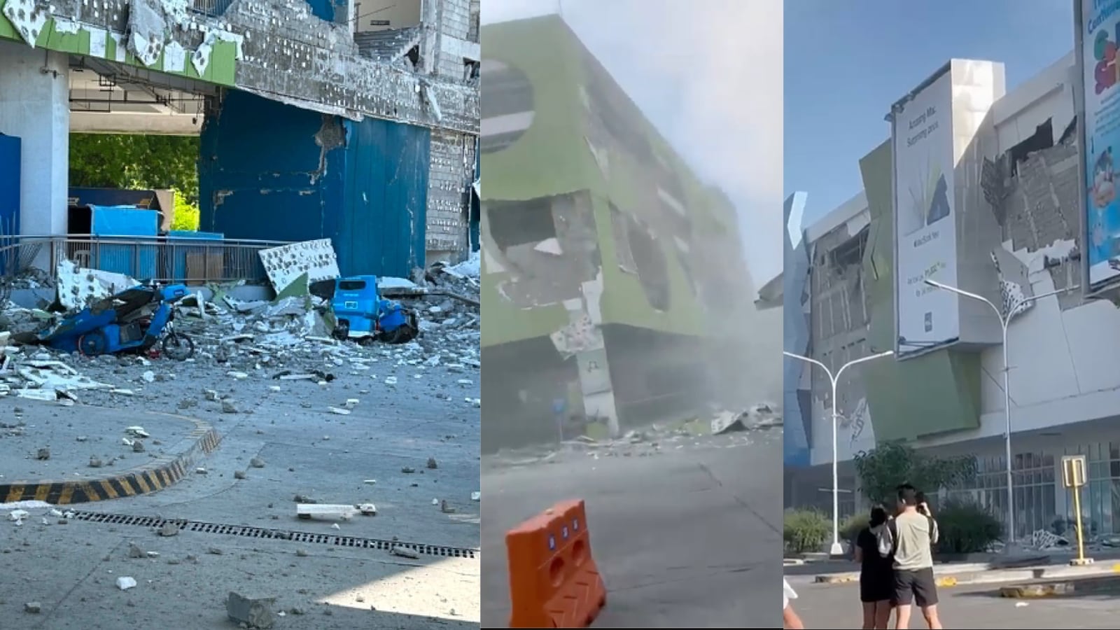
A magnitude 8.2 seismic event in the Philippine Trench represents an existential disruption to regional infrastructure, coastal logistics, and human safety. When an earthquake of this scale occurs, the immediate challenge for crisis managers, urban planners, and supply chain strategists is not just the localized shaking, but the systemic cascade of energy across oceanic basins. Understanding the precise mechanics of lithospheric rupture and subsequent hydrodynamic displacement is mandatory for executing effective mitigation and response protocols.
Evaluating an 8.2 magnitude event requires moving past sensationalized headlines and breaking down the event into quantifiable physical variables. The ultimate impact of the disaster is governed by three interconnected domains: the mechanics of the subduction zone rupture, the fluid dynamics of deep-water wave propagation, and the structural vulnerabilities of the receiving coastline. If you found value in this article, you might want to look at: this related article.
The Tri-Phasic Mechanics of Megathrust Rupture
The Philippine Sea Plate subducts beneath the Sunda Plate at a rate of approximately 50 to 80 millimeters per year. This continuous convergence builds immense elastic strain energy along the locked interface of the Philippine Trench. A magnitude 8.2 earthquake occurs when the shear stress exceeds the frictional strength of the fault plane, resulting in a rapid, catastrophic release of stored energy.
Lithospheric Displacement and Fault Geometry
The scale of a tsunami is directly proportional to the vertical deformation of the seafloor, which is dictated by the geometry of the rupture. For another perspective on this development, refer to the latest coverage from The Guardian.
- Rupture Length and Width: A magnitude 8.2 event typically requires a fault rupture length extending between 200 and 350 kilometers, with a width ranging from 50 to 100 kilometers.
- Slip Amplitude: The average slip along the fault plane during an event of this magnitude can range from 5 to 10 meters.
- Dip Angle: The Philippine Trench exhibits a relatively steep dip angle in certain segments. A steeper dip angle converts a higher percentage of the horizontal plate motion into vertical seafloor displacement, maximizing the volume of water displaced.
Water Column Displacement Chemistry
The instantaneous uplift or subsidence of the tectonic plates forces the overlying water column out of its hydrostatic equilibrium. Because water is nearly incompressible, the vertical profile of the seafloor deformation is mapped directly onto the sea surface. The potential energy injected into the water column is calculated based on the area of displacement and the height of the sea surface deformation. This initial mass displacement forms the genesis of a tsunami.
The Hydrodynamics of Deep-Ocean Tsunami Propagation
Once the water column is displaced, gravity acts as the restoring force, attempting to bring the ocean surface back to equilibrium. This triggers a series of long-period waves that propagate outward from the epicenter in all directions.
Deep-Water Wave Kinetics
In the deep ocean, tsunamis behave as shallow-water waves because their wavelength (often stretching 100 to 500 kilometers) is vastly greater than the ocean depth (typically 4 to 6 kilometers). Under these conditions, the wave velocity ($v$) is entirely dependent on the water depth ($d$) and the acceleration due to gravity ($g$), expressed via the formula:
$$v = \sqrt{gd}$$
In an ocean depth of 4,000 meters, a tsunami travels at speeds exceeding 700 kilometers per hour—comparable to the cruising speed of a commercial jetliner. Despite this immense velocity, the wave amplitude in deep water remains minimal, frequently under one meter. The energy is distributed across a massive wavelength, making the wave virtually imperceptible to ships in the open ocean.
Energy Preservation and Bathymetric Steering
Deep-ocean propagation is characterized by low energy dissipation. Because the wave energy is conserved over long distances, the tsunami can traverse thousands of kilometers across the Pacific Basin with minimal loss of destructive potential. However, the path of the wave is not entirely linear. Oceanic trenches, mid-ocean ridges, and seamounts act as bathymetric waveguides, refracting and focusing the wave energy toward specific coastal sectors while shielding others.
The Shoaling Effect and Coastal Inundation Dynamics
The true destructive capacity of a tsunami materializes as it exits the deep ocean and enters the shallow waters of the continental shelf. This transition alters the fundamental physics of the wave train.
The Physics of Shoaling
As water depth decreases, the velocity of the wave drops sharply according to the depth equation. However, the period of the wave remains constant. To conserve the total flux of wave energy, the decrease in velocity must be compensated for by an increase in wave height.
The long wavelength is compressed into a shorter, much denser package of energy. The wave amplitude grows exponentially, transforming a harmless deep-water swelling into a wall of water moving at speeds of 30 to 50 kilometers per hour upon coastal impact.
V-Shaped Bays and Resonant Amplification
The local topography of the coastline introduces critical variables that can amplify the hazard level by multiple orders of magnitude.
- Funneling Effects: When a tsunami enters a V-shaped bay, river estuary, or narrowing harbor, the lateral energy is compressed horizontally. This forces the water volume upward, resulting in a localized run-up height that can be three to four times greater than the wave height on an open, linear coastline.
- Harbor Resonance: If the natural oscillation period of a harbor or bay matches the period of the incoming tsunami waves, resonance occurs. This creates standing waves that prolong the duration of the flooding and increase the velocity of currents within the harbor, destroying maritime infrastructure.
- Drawdown: Depending on whether the fault rupture initiated with an uplift or a subsidence on the coastal side, the first manifestation of the tsunami may be a severe recession of the shoreline. This drawdown exposes the seabed for hundreds of meters, tempting untrained individuals to venture onto the exposed land before the subsequent crest arrives.
Structural Vulnerabilities and Engineering Cascades
The impact of a magnitude 8.2 earthquake followed by a tsunami creates a dual-threat scenario that tests the limits of civil engineering and critical infrastructure.
Seismic Liquefaction vs. Hydrodynamic Force
Coastal infrastructure in the Philippines must first withstand the intense ground shaking of the initial rupture. In coastal zones characterized by loose, saturated sandy soils, high-intensity shaking triggers soil liquefaction. The ground loses its shear strength and behaves like a liquid, causing foundations to fail, seawalls to crack, and port facilities to tilt.
Structures weakened by liquefaction are poorly equipped to handle the subsequent hydrodynamic forces of the tsunami. The incoming wave exerts immense hydrostatic pressure (the weight of the water standing against the structure) and hydrodynamic pressure (the force of the moving water mass). Furthermore, the wave carries heavy debris—vehicles, shipping containers, and displaced vessels—which act as battering rams, causing catastrophic structural breaches.
The Failure of Critical Lifelines
The primary driver of secondary mortality and economic paralysis following a megathrust event is the simultaneous failure of overlapping utility networks.
- The Power Grid: Substations located in low-lying coastal zones are instantly shorted and destroyed by saltwater intrusion. The loss of the electrical grid immediately deactivates localized tsunami warning sirens, communications towers, and water filtration systems.
- Transportation Corridors: Coastal highways, bridges, and rail lines are washed out or blocked by debris, isolating impacted communities and preventing emergency services from deploying resources.
- The Maritime Supply Chain: Ports and harbors are renderered non-functional due to a combination of siltation, debris accumulation, and structural damage to cranes and docks. This halts the import of medical supplies, food, and fuel.
Strategic Allocation of Early Warning and Mitigation Assets
Managing the aftermath of a magnitude 8.2 earthquake requires a systematic, non-linear deployment of early warning technologies and defensive engineering. Reliance on single-point mitigation strategies introduces critical vulnerabilities.
Deep-Ocean Assessment and Reporting Systems
Effective evacuation protocols depend on real-time data streaming from Deep-ocean Assessment and Reporting of Tsunamis (DART) buoy systems. These systems utilize a bottom pressure recorder anchored to the ocean floor that detects changes in water pressure caused by a passing tsunami. The data is transmitted acoustically to a surface buoy, which relays the information via satellite to warning centers.
[Ocean Floor Pressure Sensor] ---> (Acoustic Link) ---> [Surface Buoy] ---> (Satellite Link) ---> [Tsunami Warning Center]
The primary operational limitation of DART buoys is their spatial distribution. If the epicenter of the earthquake is located directly adjacent to the coast—as is often the case along the Philippine Trench—the time window between the seismic rupture and the first wave arrival may be less than 15 to 30 minutes. In these near-field scenarios, deep-ocean buoy data arrives too late to inform the initial evacuation order. Municipalities must rely instead on automated seismic triggers and pre-modeled inundation matrices.
Defensive Infrastructure Constraints
Constructing structural barriers such as seawalls, breakwaters, and tsunami surge gates offers localized protection but introduces distinct trade-offs. Seawalls designed for a magnitude 7.5 event will be overtopped and undermined by a magnitude 8.2 event. When a structural barrier fails, it can worsen the disaster by trapping the receding water on the landward side, prolonging the inundation period.
A resilient mitigation strategy combines structural defenses with natural ecosystems. Mangrove forests, coastal wetlands, and dense littoral vegetation act as natural shock absorbers. While they cannot stop a major tsunami, they significantly reduce the velocity and kinetic energy of the incoming wave, lowering its destructive capacity before it reaches urban zones.
Operational Protocol for Institutional Logistics
Industrial operators, maritime logistics firms, and municipal authorities must execute a highly coordinated response protocol the moment a magnitude 8.2 event is confirmed. The operational timeline is split into three immediate windows.
Zero to Fifteen Minutes: Seismic Triage and Vertical Evacuation
The immediate priority following the cessation of ground shaking is the preservation of life through rapid evacuation.
- Initiate Automated Shutdowns: Power generation facilities and gas pipelines must automatically isolate to prevent widespread fires. Heavy manufacturing equipment must be brought to a safe halt to protect structural integrity.
- Execute Vertical Evacuation Protocols: In high-density urban areas where horizontal evacuation to high ground is impossible within the 15-minute window, populations must be directed to designated Vertical Evacuation Structures (VES). These buildings must be engineered with open ground floors to allow the tsunami wave to pass through without collapsing the structure, and possess a reinforced foundation designed to withstand soil liquefaction.
- Clear Maritime Vessels: All vessels currently docked in deep-water ports must immediately head toward open water if they can clear the harbor channels before the first wave arrives. Ships in water deeper than 100 meters are significantly safer from the effects of shoaling.
Fifteen Minutes to Two Hours: Real-Time Inundation Mapping
As the wave train propagates, real-time data collection must guide the allocation of emergency resources.
- Deploy Autonomous Aerial Reconnaissance: Traditional communication infrastructure will likely be compromised. Fixed-wing autonomous drones equipped with synthetic aperture radar (SAR) must be launched to map the extent of coastal inundation through cloud cover and smoke.
- Establish Inland Logistics Hubs: Emergency staging areas must be positioned outside the maximum modeled inundation zone and above the 50-meter elevation contour. These hubs must possess independent power generation, satellite communication arrays, and helicopter landing pads to facilitate air supply lines.
Two Hours to Forty-Eight Hours: Secondary Hazard Containment
The focus shifts from immediate survival to stabilizing the region and preventing cascading environmental and industrial failures.
- Contain Hazardous Materials: Industrial zones along the coast must be secured to prevent the spill of hydrocarbons, heavy metals, and toxic chemicals into the floodwaters. Receding tsunami waters carry these contaminants back into the marine ecosystem, creating a long-term environmental crisis.
- Assess Port Infrastructure for Supply Chain Activation: Before relief vessels can deliver heavy equipment, hydrographic survey teams must map harbor channels to identify newly deposited sandbars, sunken debris, and damaged docks. Activating a single temporary pier takes precedence over attempting to repair an entire port facility.