Standard meteorological reporting consistently misinterprets the risk profile of low-velocity, poorly organized tropical cyclones. When Tropical Storm Arthur formed off the Texas coast before transitioning into an inland low-pressure system, mainstream media focused heavily on its nominal classification: a weak, short-lived storm with peak sustained winds of 45 mph. This emphasis on wind speed represents a systemic flaw in public risk communication. By prioritizing the Saffir-Simpson scale—a framework designed around wind velocity—traditional assessments fail to quantify the far more destructive variables of forward speed, precipitable water volumes, and antecedent soil moisture.
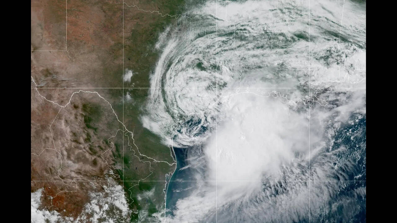
Arthur demonstrates that a storm's classification is an inaccurate predictor of its economic and human toll. While the system's low-level circulation center relocated irregularly between Matagorda County and Galveston due to asymmetric wind shear, the primary driver of damage was not wind, but a prolonged, multiday hydrological overload. Evaluating these systems requires a structural framework that treats rainfall as a function of thermodynamic capacity and geographic transit time rather than barometric intensity.
The Velocity Fallacy: Deconstructing the Rain-to-Wind Asymmetry
To understand why weak systems frequently outclass major hurricanes in localized flooding, we must isolate the variables controlling precipitation volume. Total rainfall depth at a specific geographic coordinates is determined by the interaction of atmospheric moisture density, storm diameter, and forward translational speed.
$$\text{Precipitation Depth} \propto \frac{\text{Precipitable Water} \times \text{Storm Diameter}}{\text{Forward Velocity}}$$
When a tropical system encounters a hostile environment with strong westerly wind shear, its physical structure changes fundamentally. Instead of concentrating energy into a tight, spinning eyewall, the vertical wind shear strips the deep convection away from the low-level center. This structural fragmentation spreads the moisture envelope across hundreds of miles, transforming a compact storm into an expansive, slow-moving rain generator.
The mechanics of this process unfold across three distinct phases of atmospheric and geographic interaction:
- The Precursor Saturation Phase: Days before a weak system achieves formal classification, its outer convective bands discharge continuous rainfall over coastal and inland areas. This frontloading eliminates the natural absorption capacity of local watersheds, forcing subsequent rainfall immediately into surface runoff.
- The Center Relocation Disturbance: In poorly organized storms, the low-level circulation center frequently breaks down and reforms elsewhere based on offshore convective bursts. This structural instability causes the system to stall or track erratically, extending the duration of high-intensity downpours over a singular metropolitan or agricultural corridor.
- The Remnant Trough Acceleration: As the system degrades into a post-tropical low-pressure trough, it becomes steered by mid-level atmospheric troughs. While its rotational wind fields dissipate, the remaining moisture column is pulled across adjacent states, creating an expansive swath of secondary flash flood threats far removed from the original point of landfall.
Topographic Vulnerability and the Infrastructure Bottleneck
The transition of Arthur from a coastal storm to an inland trough highlights the critical friction points within municipal drainage systems. Urban stormwater networks are engineered around specific historical return periods, typically designing infrastructure to manage 10-year or 25-year flood events. When a disorganized tropical system unloads a concentrated 5 to 10 inches of rain—with isolated localized peaks reaching up to 20 inches—the volume completely surpasses the design specifications of gravity-fed drainage channels, retention basins, and culverts.
This systemic failure manifests rapidly in low-water crossings and urban retention ponds. Civil engineering models rely on predictable infiltration rates. However, when antecedent rainfall has already driven soil saturation to 100%, the infiltration rate drops to zero. Every subsequent gallon of water functions as immediate surface runoff, converting standard streets into high-velocity drainage channels and overloading suburban retention basins beyond their engineered holding thresholds.
The systemic impact of this hydrological overload expands across a multi-state corridor as the system progresses northeastward. The following operational timeline tracks the downstream infrastructure disruptions caused by the progression of the storm's moisture column:
June 14–16: The Inland Saturation Front
Before formal classification, the precursor disturbance interacts with a stalled frontal boundary, dropping 2.72 inches of rain in Central Texas locations like Waco. Over 100 low-water crossings close across the Austin metropolitan area, and major transit routes experience immediate arterial blockages, illustrated by vehicle stalls on Interstate 35 near Robinson. Ground saturation reaches maximum capacity across east-central Texas watersheds.
June 17: Coastal Landfall and Relocation
The system officially organizes into Tropical Storm Arthur with 45 mph winds, making landfall near Matagorda County before its low-level center reforms near Galveston. Surface runoff patterns overwhelm regional drainage basins. Public infrastructure grinds to a halt as academic institutions shift operations online, and urban areas outside Houston experience lethal flash flooding in construction zones and overfilled retention ponds.
June 18: The Multi-State Trough Progression
Downgraded to a post-tropical low, the system is captured by a mid-level trough and accelerates northeastward. The primary flood threat shifts systematically away from Texas and into Louisiana, Mississippi, Alabama, and the Florida Panhandle. Municipalities in the direct path react to the advancing moisture column by preemptively closing public facilities, canceling school programs, and positioning physical barriers in historical flood zones across New Orleans and surrounding parishes.
Strategic Boundaries of Meteorological Forecasting
While modern radar networks and predictive modeling can accurately chart the broad trajectory of major hurricanes, weak and disorganized systems present a unique set of forecasting limitations. The primary challenge lies in predicting the exact locations of localized convective bursts. Because these systems lack a rigid, stable core, slight shifts in steering currents or mid-level wind shear can move the primary rain bands by 50 to 100 miles within a few hours.
Emergency management models are similarly constrained by human behavior and risk perception. The public has been conditioned to look at the category of a storm on the Saffir-Simpson scale to determine their level of preparation. A Category 4 hurricane triggers evacuations, whereas a named tropical storm that quickly downgrades to a post-tropical low prompts complacency. This creates an operational bottleneck for emergency responders: the actual hazard (life-threatening flash flooding) remains severe, but public compliance with safety alerts drops significantly because the perceived hazard (wind damage) is low.
The optimal strategy for mitigation requires a fundamental shift in institutional and corporate risk management. Rather than relying on standard storm classifications, operational leadership must evaluate weather risks through the lens of localized watershed vulnerability and supply chain transit friction. Logistics networks, manufacturing facilities, and municipal authorities must establish hard operational triggers based on cumulative rainfall forecasts and soil saturation indices rather than barometric wind designations. Organizations that continue to base their severe weather protocols solely on storm categorization will remain fundamentally exposed to the catastrophic financial and operational realities of hydrological overload.