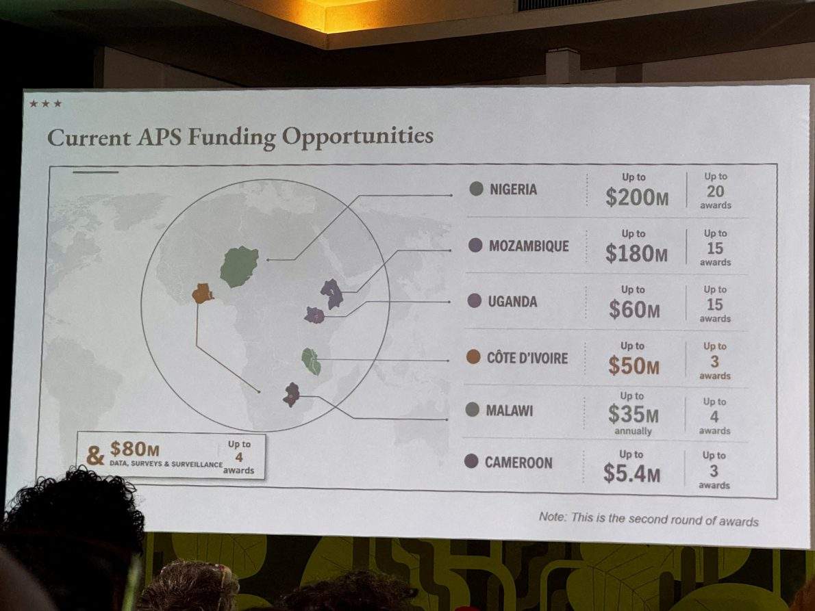
When a United States government delegation stepped onto the stage at the AIDS 2026 conference in Rio de Janeiro, Brazil, they brought more than just slide decks. They brought a visual testament to institutional carelessness. Projected onto large screens for an international audience of health officials, scientists, and activists was a map of Africa that relocated Nigeria into the arid expanses of the Sahara Desert, drifted Mozambique into the Horn of Africa, and cast Côte d'Ivoire thousands of miles away from its native Atlantic coastline. Every single country identified on the graphic was mislabelled.
The immediate public relations fallout was swift. Screenshots ricocheted across professional networks and social media platforms, transforming a high-level diplomatic presentation into an online punchline. Yet treating this cartographic catastrophe as a mere clerical slip or an isolated Photoshop oversight misses the structural rot beneath the surface. This cartographic failure is a symptom of a profound disconnect plaguing Washington foreign policy agencies. It exposes how rushed bureaucratic workflows and an over-reliance on unverified synthetic media are compromising official statecraft.
Official explanations from the State Department tried to defuse the controversy by pointing the finger downward. A spokesperson stated that an anonymous team member had hastily altered the slide deck immediately prior to the session. Accountability was accepted in the abstract, framed as an unfortunate logistical hiccup under high-pressure conditions. But this excuse collapses under even mild scrutiny. Presentations delivered at global summits by major world powers do not materialize out of thin air minutes before zero hour. They pass through multiple layers of clearance, review, and editing.
When a graphic containing such glaring geographical distortions makes it past every internal gatekeeper, it signals an alarming vacuum of institutional competence. More tellingly, an analysis by technical investigators revealed that the offending graphic bore an artificial intelligence watermark linked to OpenAI tools. The deployment of generative models for sovereign cartography is an administrative hazard. Generative systems are notorious for hallucinating spatial relationships, text, and geopolitical boundaries when tasked with complex geographical data.
To rely on a machine-generated image of a foreign continent without basic human verification is a failure of baseline due diligence. For the international community, the visual error felt less like a clumsy accident and more like an active expression of administrative indifference. African health ministers, policy experts, and local partners sat in that Rio de Janeiro auditorium watching a superpower attempt to dictate the future architecture of HIV/AIDS funding while demonstrating an inability to correctly locate the nations carrying the heaviest burdens of the epidemic.
This visual blunder arrived at a uniquely volatile moment for global health equity. The United States remains the primary financial engine behind international HIV/AIDS interventions, largely through the President's Emergency Plan for AIDS Relief, commonly known as PEPFAR. However, the program has faced severe institutional disruption and budget scaling following recent transitions in Washington. The Rio de Janeiro conference was designed to outline new funding agreements, strategic phase-outs, and bilateral partnerships intended to reshape how prevention and surveillance are handled across the African continent.
Activists and policy analysts on the ground noted that the presentation sought to repackage retrenchment as innovation. Long-standing cooperative frameworks and institutional supports established by agencies like the Centers for Disease Control and Prevention were glossed over or recast as fresh administrative achievements. When an administration is actively downsizing its global footprint and shifting responsibilities away from multilateral coordination, the margin for diplomatic grace is razor-thin. Mislabeling a continent is a catastrophic public relations failure, but it compounds into a diplomatic insult when paired with announcements of reduced health funding and structural withdrawal.
The incident has also forced a reckoning over the integration of generative systems into government workflows. As agencies face internal downsizing and pressure to produce materials faster with fewer personnel, the temptation to bypass traditional design processes in favor of rapid automated tools grows stronger. Yet government communications carry legal, diplomatic, and symbolic weight. A private enterprise utilizing faulty automated assets might suffer minor brand embarrassment. When a sovereign government deploys unverified synthetic imagery at a premier United Nations-associated global summit, it broadcasts a dangerous institutional message that accuracy is optional.
International relations depend on precision. Boundaries, names, and regional sovereignty are not aesthetic choices; they are the foundational language of diplomacy. When that language is scrambled by an automated generator and rubber-stamped by exhausted staffers, trust erodes. The State Department can issue formal regrets and characterize the episode as an unfortunate lapse, but the deeper institutional reality remains exposed. If the apparatus of state cannot maintain basic geographical accuracy on a presentation slide, the international community has every right to question its precision when managing matters of life, death, and global health security.